|
Volcanic Vent in the Tharsis Region
- Click the image above for a larger view
- Full-Res JPEG (2048 x 2743) (493.4 kB)
- Full-Res TIFF (2048 x 2743) (5.6 MB)
Caption:

Click on image for larger version
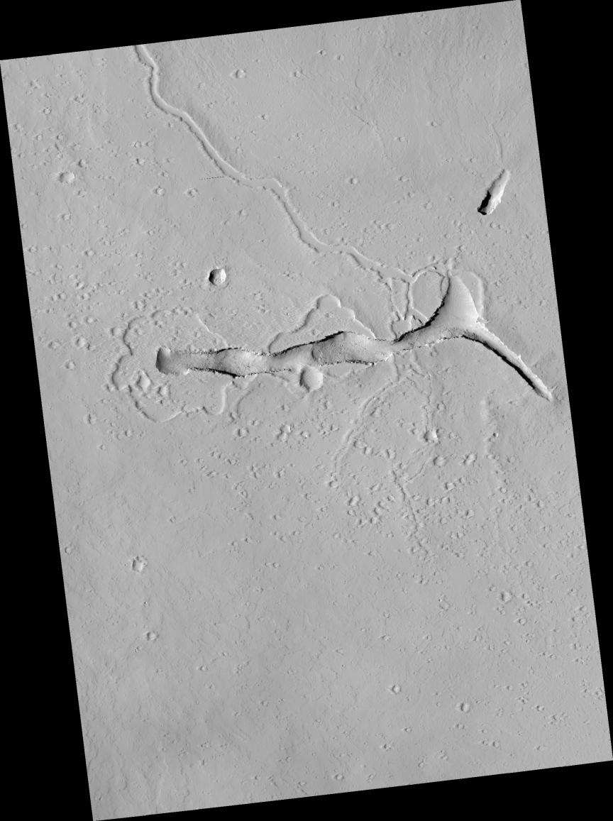
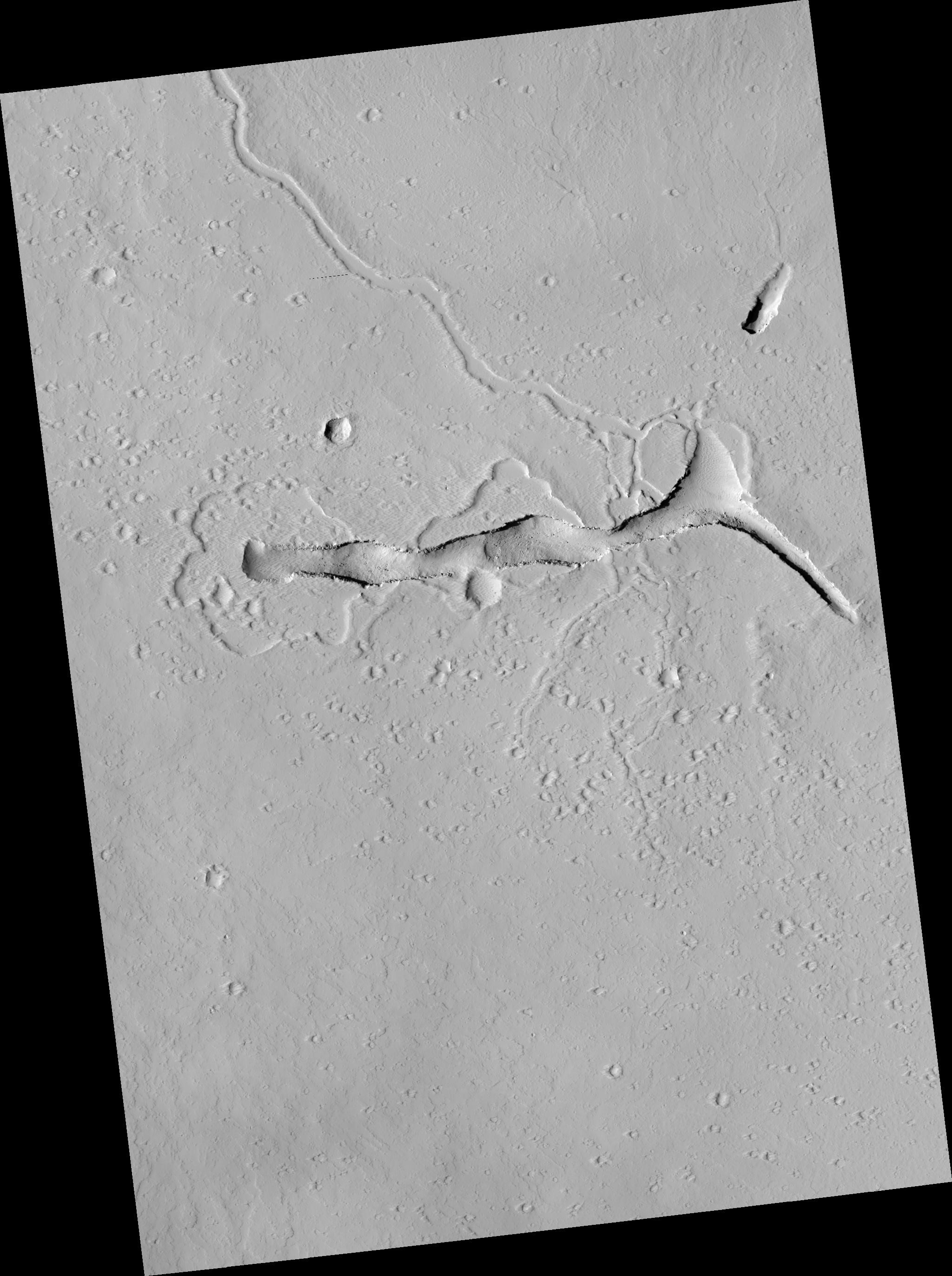
This HiRISE image shows a volcanic vent in the Tharsis region of Mars.
Tharsis is primarily a volcanic highland, containing several of the largest shield volcanoes in the Solar System and many smaller volcanic edifices.
rise is riddled with faults and fractures. The area depicted in the sub-image (above) lies between three sets of fractures -- the Cyane Fossae, the Ceraunius Fossae, and the Olympic Fossae -- and on the flank of a low volcanic shield. The prominent trough in the HiRISE image is a volcanic vent.
Shallow depressions with scalloped edges span the western (left) half of the vent. These may be places where lakes of lava once stood. The lava that ponded in the lakes probably drained back into the vent towards the end of the eruption. On the eastern (right) side of the sub-image, small channels that once transported lava feed away from the vent to both the north and south.
Originally, the vent must have been a deep and narrow fissure, but it has become more trough-like with time as material tumbled from its walls and settled on its floor. This "mass wasting" process has exposed lava flows in cross section in the walls of the trough.
Observation Geometry
Image
PSP_001695_2080
was taken by the High Resolution Imaging Science Experiment (HiRISE) camera onboard the Mars Reconnaissance Orbiter spacecraft on 06-Dec-2006. The complete image is centered at 27.6 degrees latitude, 246.9 degrees East longitude. The range to the target site was 280.4 km (175.3 miles). At this distance the image scale is 28.1 cm/pixel (with 1 x 1 binning) so objects ~84 cm across are resolved. The image shown here has been map-projected to 25 cm/pixel and north is up. The image was taken at a local Mars time of 03:29 PM and the scene is illuminated from the west with a solar incidence angle of 51 degrees, thus the sun was about 39 degrees above the horizon. At a solar longitude of 146.2 degrees, the season on Mars is Northern Summer.
Background Info:
NASA's Jet Propulsion Laboratory, a division of the California Institute of Technology in Pasadena, manages the Mars Reconnaissance Orbiter for NASA's Science Mission Directorate, Washington. Lockheed Martin Space Systems, Denver, is the prime contractor for the project and built the spacecraft. The High Resolution Imaging Science Experiment is operated by the University of Arizona, Tucson, and the instrument was built by Ball Aerospace and Technology Corp., Boulder, Colo.
Cataloging Keywords:
| Name | Value | Additional Values |
|---|---|---|
| Target | Mars | |
| System | ||
| Target Type | Planet | |
| Mission | Mars Reconnaissance Orbiter (MRO) | |
| Instrument Host | Mars Reconnaissance Orbiter | |
| Host Type | Orbiter | |
| Instrument | High Resolution Imaging Science Experiment (HiRISE) | |
| Detector | ||
| Extra Keywords | Grayscale, Map, Rotation, Volcano | |
| Acquisition Date | ||
| Release Date | 2007-01-17 | |
| Date in Caption | ||
| Image Credit | NASA/JPL/Univ. of Arizona | |
| Source | photojournal.jpl.nasa.gov/catalog/PIA09568 | |
| Identifier | PIA09568 | |