|
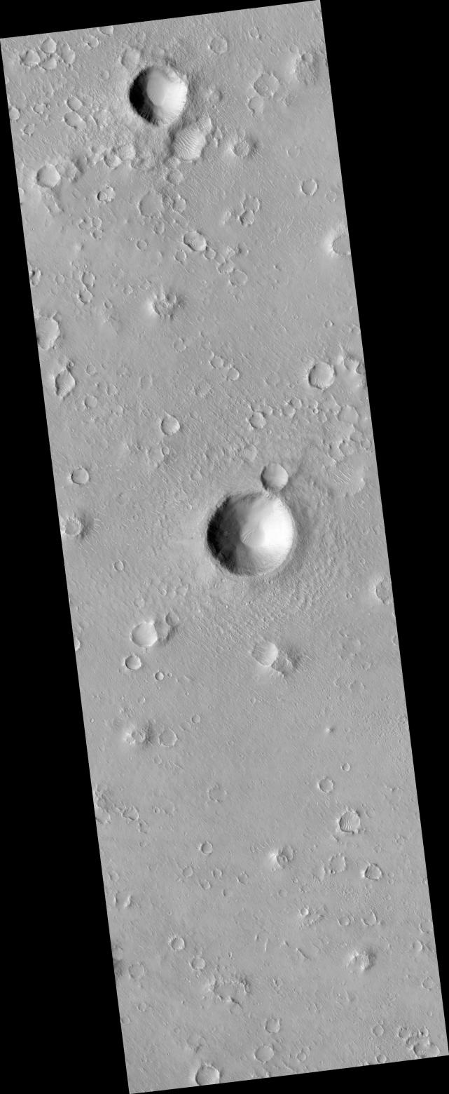
Portion of Beagle 2 Landing Ellipse in Isidis Planitia
- Click the image above for a larger view
- Full-Res JPEG (2048 x 4983) (959.6 kB)
- Full-Res TIFF (2048 x 4983) (10.2 MB)
Caption:
This image ( PSP_002347_1915 ) was targeted to a dark spot seen in a MOC image that was suggested to be the Beagle 2 landing site (see Beagle 2 Landing Site Located for more information).
The dark spot corresponds to an impact crater, shown here in color. The European Beagle 2 lander was carried by the Mars Express orbiting spacecraft and released into the Martian atmosphere in December 2003, but
Observation Geometry
Acquisition date:
1 January 2007
Local Mars time:
3:40 PM
Degrees latitude (centered):
11.7 °
Degrees longitude (East):
90.7 °
Range to target site:
278.3 km (173.9 miles)
Original image scale range:
27.8 cm/pixel (with 1 x 1 binning) so objects ~84 cm across are resolved
Map-projected scale:
25 cm/pixel and north is up
Map-projection:
EQUIRECTANGULAR
Emission angle:
3.3 °
Phase angle:
51.9 °
Solar incidence angle:
55 °, with the Sun about 35 ° above the horizon
Solar longitude:
173.1 °, Northern Summer
Background Info:
NASA's Jet Propulsion Laboratory, a division of the California Institute of Technology in Pasadena, manages the Mars Reconnaissance Orbiter for NASA's Science Mission Directorate, Washington. Lockheed Martin Space Systems, Denver, is the prime contractor for the project and built the spacecraft. The High Resolution Imaging Science Experiment is operated by the University of Arizona, Tucson, and the instrument was built by Ball Aerospace and Technology Corp., Boulder, Colo.
Cataloging Keywords:
| Name | Value | Additional Values |
|---|---|---|
| Target | Mars | |
| System | ||
| Target Type | Planet | |
| Mission | Mars Reconnaissance Orbiter (MRO) | Mars Express, Mars Express (MEX), Mars Global Surveyor (MGS) |
| Instrument Host | Mars Reconnaissance Orbiter | Mars Express Lander, Mars Express Orbiter, Mars Global Surveyor |
| Host Type | Orbiter | Lander |
| Instrument | High Resolution Imaging Science Experiment (HiRISE) | Mars Orbiter Camera (MOC) |
| Detector | ||
| Extra Keywords | Atmosphere, Crater, Grayscale, Impact, Infrared, Map, Storm | |
| Acquisition Date | ||
| Release Date | 2007-02-14 | |
| Date in Caption | 2007-01-01 | |
| Image Credit | NASA/JPL/University of Arizona | |
| Source | photojournal.jpl.nasa.gov/catalog/PIA09592 | |
| Identifier | PIA09592 | |