
|
Northern Hemisphere Gullies with Layers
- Click the image above for a larger view
- Full-Res JPEG (2048 x 6080) (1.5 MB)
- Full-Res TIFF (2048 x 6080) (12.5 MB)
Caption:
Click on image for larger version
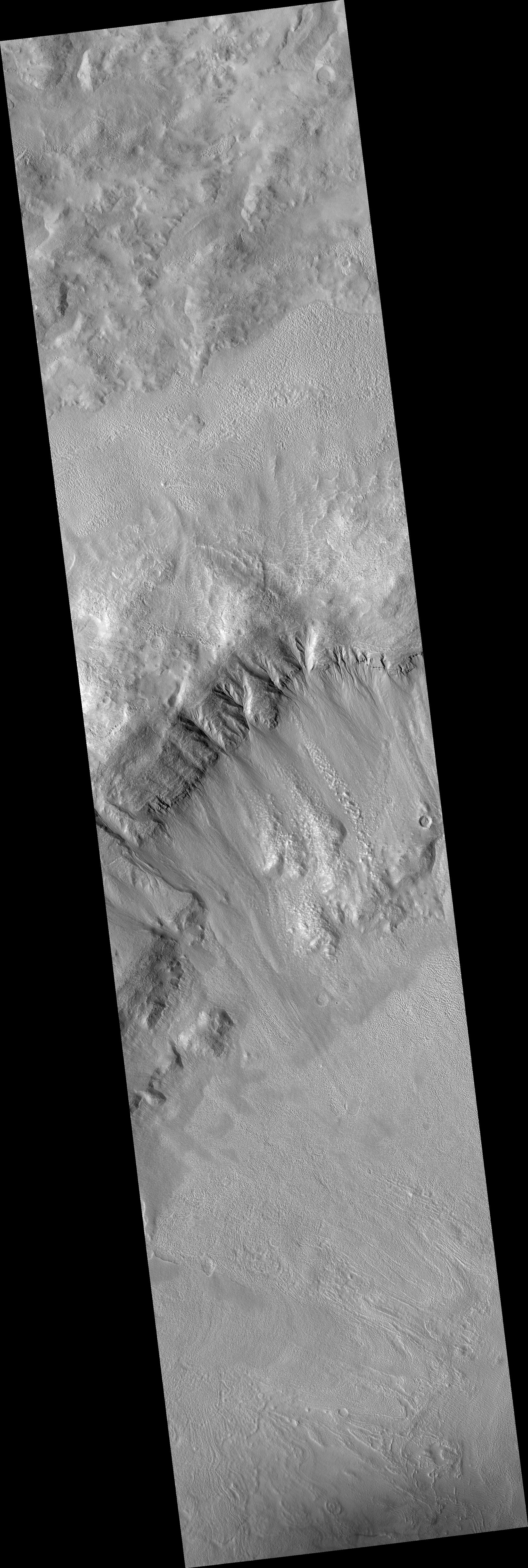
This HiRISE image ( PSP_001528_2210 ) shows northern hemisphere gullies on a layered crater wall.
Many channels can be seen emanating from beneath layers suggesting that the layers are permeable and carried water to the slope face via the subsurface. It is also possible that the source of water came from the surface. The gullies that do not originate at a layer likely did at one time and have subsequently experienced headward erosion, eroding the layers upslope of their original location.
A mantled unit (smooth terrain) can be seen above the sources of and within many of the gullies in this image. The mantled unit has been proposed to be remnant snowpack that melts at its bottom to carve gullies. The mantled unit is less abundant in locations where the gullies are most deeply incised, which supports the melting snowpack theory.
Deeper incision typically involves more water and/or more flow events. If the mantled unit is the source of the liquid for the gullies, then it is expected that locations with evidence of larger or more frequent flows would be associated with regions of less mantled unit. It is unknown whether the mantled unit can insulate the surface sufficiently to allow temperatures and pressures appropriate for liquid water formation. An answer to this awaits future modeling of snowpack under Martian conditions.
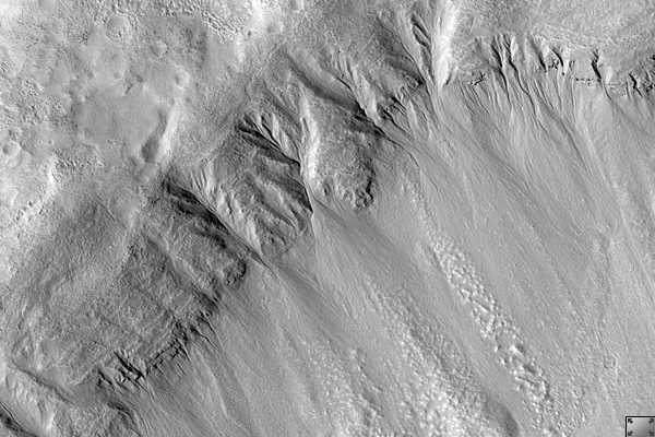
Within the subimage, channels can clearly be seen to originate at a variety of layers. Also noticeable is the smooth, mantled material located between layers above these gullies.
Observation Geometry
Acquisition date:
11 November 2006
Local Mars time:
3:22 PM
Degrees latitude (centered):
40.6 °
Degrees longitude (East):
120.1 °
Range to target site:
298.8 km (186.8 miles)
Original image scale range:
29.9 cm/pixel (with 1 x 1 binning) so objects ~90 cm across are resolved
Map-projected scale:
25 cm/pixel and north is up
Map-projection:
EQUIRECTANGULAR
Emission angle:
2.3 °
Phase angle:
52.3 °
Solar incidence angle:
50 °, with the Sun about 40 ° above the horizon
Solar longitude:
139.7 °, Northern Summer
Background Info:
NASA's Jet Propulsion Laboratory, a division of the California Institute of Technology in Pasadena, manages the Mars Reconnaissance Orbiter for NASA's Science Mission Directorate, Washington. Lockheed Martin Space Systems, Denver, is the prime contractor for the project and built the spacecraft. The High Resolution Imaging Science Experiment is operated by the University of Arizona, Tucson, and the instrument was built by Ball Aerospace and Technology Corp., Boulder, Colo.
Cataloging Keywords:
| Name | Value | Additional Values |
|---|---|---|
| Target | Mars | |
| System | ||
| Target Type | Planet | |
| Mission | Mars Reconnaissance Orbiter (MRO) | |
| Instrument Host | Mars Reconnaissance Orbiter | |
| Host Type | Orbiter | |
| Instrument | High Resolution Imaging Science Experiment (HiRISE) | |
| Detector | ||
| Extra Keywords | Crater, Grayscale, Infrared, Map, Water | |
| Acquisition Date | ||
| Release Date | 2007-02-14 | |
| Date in Caption | 2006-11-11 | |
| Image Credit | NASA/JPL/University of Arizona | |
| Source | photojournal.jpl.nasa.gov/catalog/PIA09599 | |
| Identifier | PIA09599 | |