|
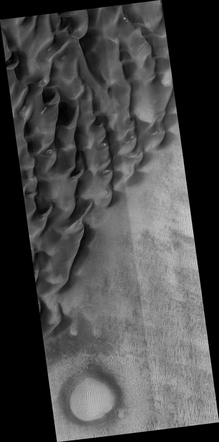
Proctor Crater Dune Field
- Click the image above for a larger view
- Full-Res JPEG (2048 x 4131) (872.8 kB)
- Full-Res TIFF (2048 x 4131) (8.5 MB)
Caption:

Click on image for larger version
Image ( PSP_002455_1320 ) shows the edge of a dark dune field on the floor of Proctor crater, a 150 kilometer diameter crater in the southern highlands of Mars.
The subimage is a close-up view of the dark dunes. These dunes are most likely composed of basaltic sand that has collected on the bottom of the crater. Superimposed on their surface are smaller secondary dunes which are commonly seen on terrestrial dunes of this size. Near the crests of the dark dunes are bright patches of frost. Dark spots within the frost patches are areas where defrosting is occurring.
Many smaller and brighter bed forms, most likely small dunes or granule ripples, cover the substrate between the larger dark dunes as well as most of the floor of Proctor Crater. In many locations, large boulders are seen on the same surfaces as the bright bed forms. The dark dunes stratigraphically overlie the small bright bed forms indicating that the darker dunes formed more recently.
However in several areas, the dark dunes appear to influence the orientation of the small bright dunes, possibly by wind flowing around the larger dunes, suggesting that both dark and bright bed forms are coeval.
Observation Toolbox:
Acquisition date:
2 February 2007
Local Mars time:
3:56 PM
Degrees latitude (centered):
-47.8°
Degrees longitude (East):
30.7°
Range to target site:
253.5 km (158.4 miles)
Original image scale range:
25.4 cm/pixel (with 1 x 1 binning) so objects ~76 cm across are resolved
Map-projected scale:
25 cm/pixel and north is up
Map-projection:
EQUIRECTANGULAR
Emission angle:
6.8°
Phase angle:
65.1°
Solar incidence angle:
71°, with the Sun about 19° above the horizon
Solar longitude:
177.7°, Northern Autumn
Background Info:
NASA's Jet Propulsion Laboratory, a division of the California Institute of Technology in Pasadena, manages the Mars Reconnaissance Orbiter for NASA's Science Mission Directorate, Washington. Lockheed Martin Space Systems, Denver, is the prime contractor for the project and built the spacecraft. The High Resolution Imaging Science Experiment is operated by the University of Arizona, Tucson, and the instrument was built by Ball Aerospace and Technology Corp., Boulder, Colo.
Cataloging Keywords:
| Name | Value | Additional Values |
|---|---|---|
| Target | Mars | |
| System | ||
| Target Type | Planet | |
| Mission | Mars Reconnaissance Orbiter (MRO) | |
| Instrument Host | Mars Reconnaissance Orbiter | |
| Host Type | Orbiter | |
| Instrument | High Resolution Imaging Science Experiment (HiRISE) | |
| Detector | ||
| Extra Keywords | Atmosphere, Crater, Dune, Grayscale, Infrared, Map, Storm | |
| Acquisition Date | ||
| Release Date | 2007-02-21 | |
| Date in Caption | 2007-02-02 | |
| Image Credit | NASA/JPL/University of Arizona | |
| Source | photojournal.jpl.nasa.gov/catalog/PIA09606 | |
| Identifier | PIA09606 | |