|
Layers in Terby Crater
- Click the image above for a larger view
- Full-Res JPEG (2048 x 3422) (577.0 kB)
- Full-Res TIFF (2048 x 3422) (7.0 MB)
Caption:
Click on image for larger version
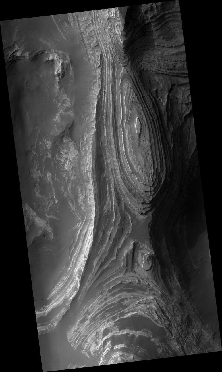
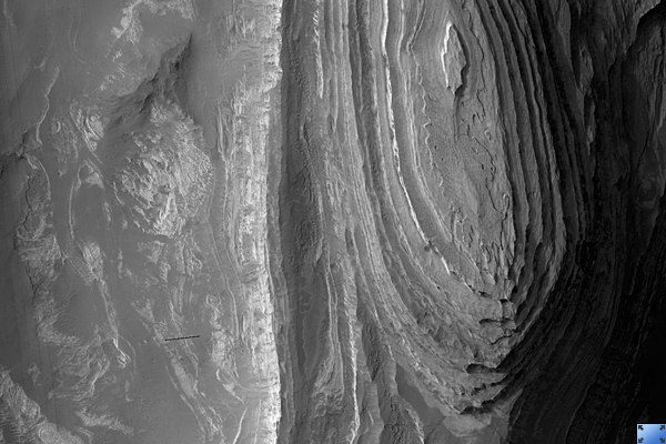
This HiRISE image ( PSP_001596_1525 ) shows a sequence of predominantly light-toned, layered, sedimentary rocks exposed by erosion on the floor of Terby Crater. Terby Crater is ~165 kilometers (~100 miles) in diameter. It's located on the northern rim of the Hellas impact basin in the southern hemisphere of Mars.
The layered sequence is ~2 kilometers (~1.2 miles) thick and consists of many repetitive, relatively horizontal beds. The beds appear to be laterally continuous, which means you can identify a given layer in many locations across the area.
Details in the layering seen in this HiRISE image reveal variations in the brightness of the layers and may indicate differing mineralogies. Based on the ease with which wind appears to erode these layers, they are believed to be composed mostly of fine-grained sediments. However, one or more of the beds is weathering to form meter (yard)-scale boulders that have accumulated downslope in fans of debris (see subimage , full resolution, approx. 200 m [218 yards] across). These larger boulders indicate the material in the layers may be stronger than just fine-grained sediments.
It's not clear how these layers formed, but it may have involved deposition by wind or volcanic activity. Another theory involves all or part of the Hellas basin being filled with ice-covered lakes at one time in the past. The layers we see may have formed as material that was suspended in the water dropped down to the bottom of the lake.
Observation Toolbox
Acquisition date:
11 November 2006
Local Mars time:
3:38 PM
Degrees latitude (centered):
-27.3°
Degrees longitude (East):
74.3°
Range to target site:
256.5 km (160.3 miles)
Original image scale range:
25.7 cm/pixel (with 1 x 1 binning) so objects ~77 cm across are resolved
Map-projected scale:
25 cm/pixel and north is up
Map-projection:
EQUIRECTANGULAR
Emission angle:
0.3°
Phase angle:
68.1°
Solar incidence angle:
68°, with the Sun about 22° above the horizon
Solar longitude:
142.3°, Northern Autumn
Background Info:
NASA's Jet Propulsion Laboratory, a division of the California Institute of Technology in Pasadena, manages the Mars Reconnaissance Orbiter for NASA's Science Mission Directorate, Washington. Lockheed Martin Space Systems, Denver, is the prime contractor for the project and built the spacecraft. The High Resolution Imaging Science Experiment is operated by the University of Arizona, Tucson, and the instrument was built by Ball Aerospace and Technology Corp., Boulder, Colo.
Cataloging Keywords:
| Name | Value | Additional Values |
|---|---|---|
| Target | Mars | |
| System | ||
| Target Type | Planet | |
| Mission | Mars Reconnaissance Orbiter (MRO) | |
| Instrument Host | Mars Reconnaissance Orbiter | |
| Host Type | Orbiter | |
| Instrument | High Resolution Imaging Science Experiment (HiRISE) | |
| Detector | ||
| Extra Keywords | Crater, Grayscale, Impact, Infrared, Map, Volcano, Water | |
| Acquisition Date | ||
| Release Date | 2007-04-18 | |
| Date in Caption | 2006-11-11 | |
| Image Credit | NASA/JPL/Univ. of Arizona | |
| Source | photojournal.jpl.nasa.gov/catalog/PIA09663 | |
| Identifier | PIA09663 | |