skip to navigation

|
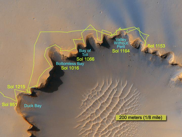
Crater Rim Path, Sol 1,215
- Click the image above for a larger view
- Full-Res JPEG (720 x 540) (46.7 kB)
- Full-Res TIFF (720 x 540) (1.2 MB)
Caption:
The route followed by NASA's Mars Exploration Rover Opportunity during its exploration partway around the rim of Victoria Crater is marked on this map. The rover first reached the edge of the crater on it's 951st Martian day, or sol (Sept. 26, 2006). This map shows travels through sol 1,215 (June 24, 2007). The underlying image is from the High Resolution Imaging Science Experiment (HiRISE) camera on NASA's Mars Reconnaissance Orbiter.
Cataloging Keywords:
| Name | Value | Additional Values |
|---|---|---|
| Target | Mars | |
| System | ||
| Target Type | Planet | |
| Mission | Mars Exploration Rover (MER) | Mars Reconnaissance Orbiter (MRO) |
| Instrument Host | Mars Reconnaissance Orbiter | Opportunity (MER-B) |
| Host Type | Orbiter | Rover |
| Instrument | High Resolution Imaging Science Experiment (HiRISE) | |
| Detector | ||
| Extra Keywords | Color, Crater, Map | |
| Acquisition Date | ||
| Release Date | 2007-06-28 | |
| Date in Caption | 2007-06-24 | |
| Image Credit | NASA/JPL/University of Arizona/Ohio State University | |
| Source | photojournal.jpl.nasa.gov/catalog/PIA09696 | |
| Identifier | PIA09696 | |