|
Terrain Type for Phoenix Landing
- Click the image above for a larger view
- Full-Res JPEG (720 x 415) (73.3 kB)
- Full-Res TIFF (720 x 415) (299.3 kB)
Caption:
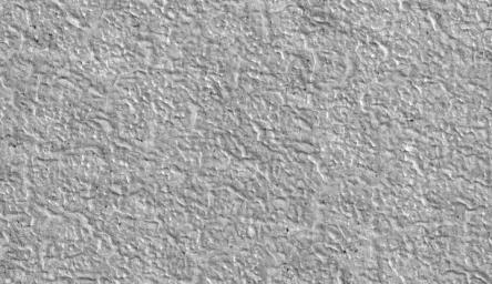
This view shows the texture of the ground in the area favored as a landing site for NASA's Phoenix Mars Lander mission. The pattern resembles permafrost terrain on Earth, where cycles of thawing and freezing cause cracking into polygon shapes.
This is a subframe, covering a patch of ground about 700 meters (2,300 feet) across, from a larger image taken by the High Resolution Imaging Science Experiment (HiRISE) camera on NASA's Mars Reconnaissance Orbiter on Nov. 11, 2006. The full image, catalogued as PSP_001418_2495 , shows an area of far-northern Mars centered at 69.2 degrees north latitude, 234.2 degrees east longitude.
Background Info:
NASA's Jet Propulsion Laboratory, a division of the California Institute of Technology in Pasadena, manages the Mars Reconnaissance Orbiter for NASA's Science Mission Directorate, Washington. Lockheed Martin Space Systems, Denver, is the prime contractor for the project and built the spacecraft. The High Resolution Imaging Science Experiment is operated by the University of Arizona, Tucson, and the instrument was built by Ball Aerospace and Technology Corp., Boulder, Colo.
Photojournal Note: As planned, the Phoenix lander, which landed May 25, 2008 23:53 UTC, ended communications in November 2008, about six months after landing, when its solar panels ceased operating in the dark Martian winter.
Cataloging Keywords:
| Name | Value | Additional Values |
|---|---|---|
| Target | Mars | |
| System | ||
| Target Type | Planet | |
| Mission | Mars Reconnaissance Orbiter (MRO) | Phoenix |
| Instrument Host | Mars Reconnaissance Orbiter | Phoenix Lander |
| Host Type | Orbiter | Lander |
| Instrument | High Resolution Imaging Science Experiment (HiRISE) | |
| Detector | ||
| Extra Keywords | Grayscale | |
| Acquisition Date | ||
| Release Date | 2007-07-09 | |
| Date in Caption | 2006-11-11 | |
| Image Credit | NASA/JPL-Caltech/University of Arizona | |
| Source | photojournal.jpl.nasa.gov/catalog/PIA09702 | |
| Identifier | PIA09702 | |
