|
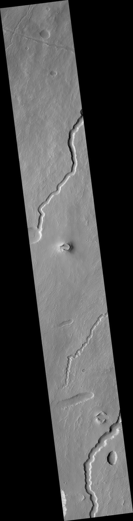
Possible Cinder Cone on the Southern Flank of Pavonis Mons
- Click the image above for a larger view
- Full-Res JPEG (2048 x 8017) (1.1 MB)
- Full-Res TIFF (2048 x 8017) (16.4 MB)
Caption:

Click on image for larger version
This HiRISE image ( PSP_002671_1790 ) is centered on a small cone on the side of one of Mars' giant shield volcanoes. The cone shows some layers of hard rock but most of it is made of relatively soft material. This appears to be an example of a "cinder" cone composed of pieces of lava thrown into the air during a small volcanic eruption.
Typically, such eruptions produce fountains of molten lava. Most of the lava would have cooled in this fountain, producing a loose pile of lava rocks. However, it appears that some pulses of the eruption allowed the lava to land without cooling much. These pieces were hot enough to weld together to make the hard layers we see today. The cone is 700 x 1100 m (2300 x 3600 feet) in size, similar to many cinder cones on Earth.
In other parts of the image, we see channels carved by lava. It is sometimes difficult to tell if a channel was formed by flowing water or lava; in this case, it is possible to see that lava flows feed out of these channels.
Observation Toolbox
Acquisition date:
2 February 2007
Local Mars time:
3:43 PM
Degrees latitude (centered):
-1.1°
Degrees longitude (East):
246.6°
Range to target site:
254.5 km (159.1 miles)
Original image scale range:
50.9 cm/pixel (with 2 x 2 binning) so objects ~153 cm across are resolved
Map-projected scale:
50 cm/pixel and north is up
Map-projection:
EQUIRECTANGULAR
Emission angle:
2.6°
Phase angle:
53.3°
Solar incidence angle:
56°, with the Sun about 34° above the horizon
Solar longitude:
187.3°, Northern Autumn
Background Info:
NASA's Jet Propulsion Laboratory, a division of the California Institute of Technology in Pasadena, manages the Mars Reconnaissance Orbiter for NASA's Science Mission Directorate, Washington. Lockheed Martin Space Systems, Denver, is the prime contractor for the project and built the spacecraft. The High Resolution Imaging Science Experiment is operated by the University of Arizona, Tucson, and the instrument was built by Ball Aerospace and Technology Corp., Boulder, Colo.
Cataloging Keywords:
| Name | Value | Additional Values |
|---|---|---|
| Target | Mars | |
| System | ||
| Target Type | Planet | |
| Mission | Mars Reconnaissance Orbiter (MRO) | |
| Instrument Host | Mars Reconnaissance Orbiter | |
| Host Type | Orbiter | |
| Instrument | High Resolution Imaging Science Experiment (HiRISE) | |
| Detector | ||
| Extra Keywords | Grayscale, Infrared, Map, Mountain, Volcano, Water | |
| Acquisition Date | ||
| Release Date | 2007-05-30 | |
| Date in Caption | 2007-02-02 | |
| Image Credit | NASA/JPL/Univ. of Arizona | |
| Source | photojournal.jpl.nasa.gov/catalog/PIA09719 | |
| Identifier | PIA09719 | |