|
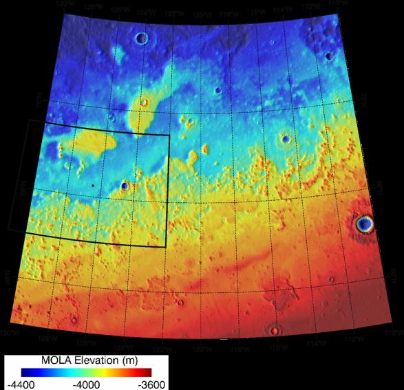
Topographical Context of Phoenix Landing Region
- Click the image above for a larger view
- Full-Res JPEG (1019 x 985) (137.0 kB)
- Full-Res TIFF (1019 x 985) (3.0 MB)
Caption:
Color coding indicates the topography in this map of the region of Mars from 65 to 72 degrees north latitude and from 230 to 250 degrees east longitude. This area was designated "Region D" in the process of evaluating potential landing sites for NASA's Phoenix Mars Lander. The location chosen for safe landing sites is within the box bordered with a heavy black line along the western boundary of this region.
Elevation in the region varies from about 3,600 meters (11,800 feet) to 4,400 meters (14,400 feet) below the zero reference point for Martian surface elevation. The topographical information is from the Mars Orbiter Laser Altimeter on NASA's Mars Global Surveyor orbiter.
Background Info:
Photojournal Note: As planned, the Phoenix lander, which landed May 25, 2008 23:53 UTC, ended communications in November 2008, about six months after landing, when its solar panels ceased operating in the dark Martian winter.
Cataloging Keywords:
| Name | Value | Additional Values |
|---|---|---|
| Target | Mars | |
| System | ||
| Target Type | Planet | |
| Mission | Mars Global Surveyor (MGS) | Phoenix |
| Instrument Host | Mars Global Surveyor | Phoenix Lander |
| Host Type | Orbiter | Lander |
| Instrument | Mars Orbiter Laser Altimeter (MOLA) | |
| Detector | ||
| Extra Keywords | Color, Map | |
| Acquisition Date | ||
| Release Date | 2007-08-02 | |
| Date in Caption | ||
| Image Credit | NASA/JPL-Caltech/Washington Univ. St. Louis/Univ. of Arizona | |
| Source | photojournal.jpl.nasa.gov/catalog/PIA09945 | |
| Identifier | PIA09945 | |