
|
Possible Landing Ellipses for Phoenix
- Click the image above for a larger view
- Full-Res JPEG (1159 x 858) (191.5 kB)
- Full-Res TIFF (1159 x 858) (3.0 MB)
Caption:
Annotated Version
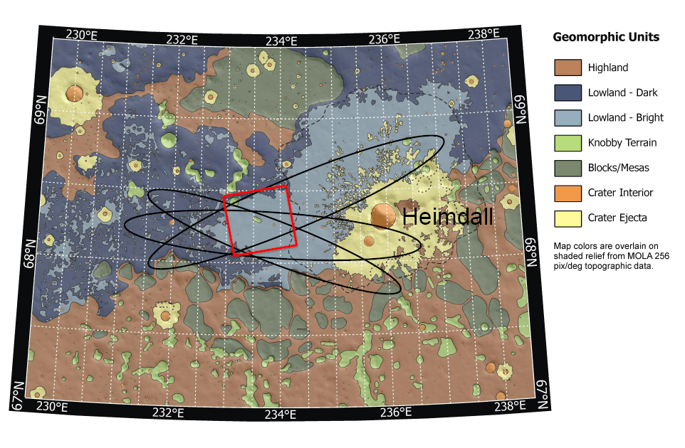
Launch date makes a difference in the orientation of ellipses marking where NASA's Phoenix Mars Lander will have a high probability of landing, given the planned targeting for the spring 2008 landing site. This map shows possible landing ellipses for the Aug. 3, 2007, opening of the launch period (the ellipse oriented northwest to southeast) and for launch dates at the middle and end of the three-week period of launch opportunities.
The map also shows a color-coded interpretation of geomorphic units -- categories based on the surface textures and contours. The yellow-coded area surrounding a crater informally named "Heimdall" appears to have even fewer boulders on the surface than other units. The geomorphic mapping is overlaid on a shaded relief map based on data from the Mars Orbiter Laser Altimeter on NASA's Mars Global Surveyor orbiter. The red box indicates the location of an image PIA09947 from the Context Camera on NASA's Mars Reconnaissance Orbiter.
Background Info:
Photojournal Note: As planned, the Phoenix lander, which landed May 25, 2008 23:53 UTC, ended communications in November 2008, about six months after landing, when its solar panels ceased operating in the dark Martian winter.
Cataloging Keywords:
| Name | Value | Additional Values |
|---|---|---|
| Target | Mars | |
| System | ||
| Target Type | Planet | |
| Mission | Mars Reconnaissance Orbiter (MRO) | Mars Global Surveyor (MGS), Phoenix |
| Instrument Host | Mars Reconnaissance Orbiter | Mars Global Surveyor, Phoenix Lander |
| Host Type | Orbiter | Lander |
| Instrument | Context Camera (CTX) | |
| Detector | ||
| Extra Keywords | Color, Crater, Map | |
| Acquisition Date | ||
| Release Date | 2007-08-02 | |
| Date in Caption | 2007-08-03 | |
| Image Credit | NASA/JPL-Caltech/Washington Univ. St. Louis/JHU APL/Univ. of Arizona | |
| Source | photojournal.jpl.nasa.gov/catalog/PIA09946 | |
| Identifier | PIA09946 | |