|
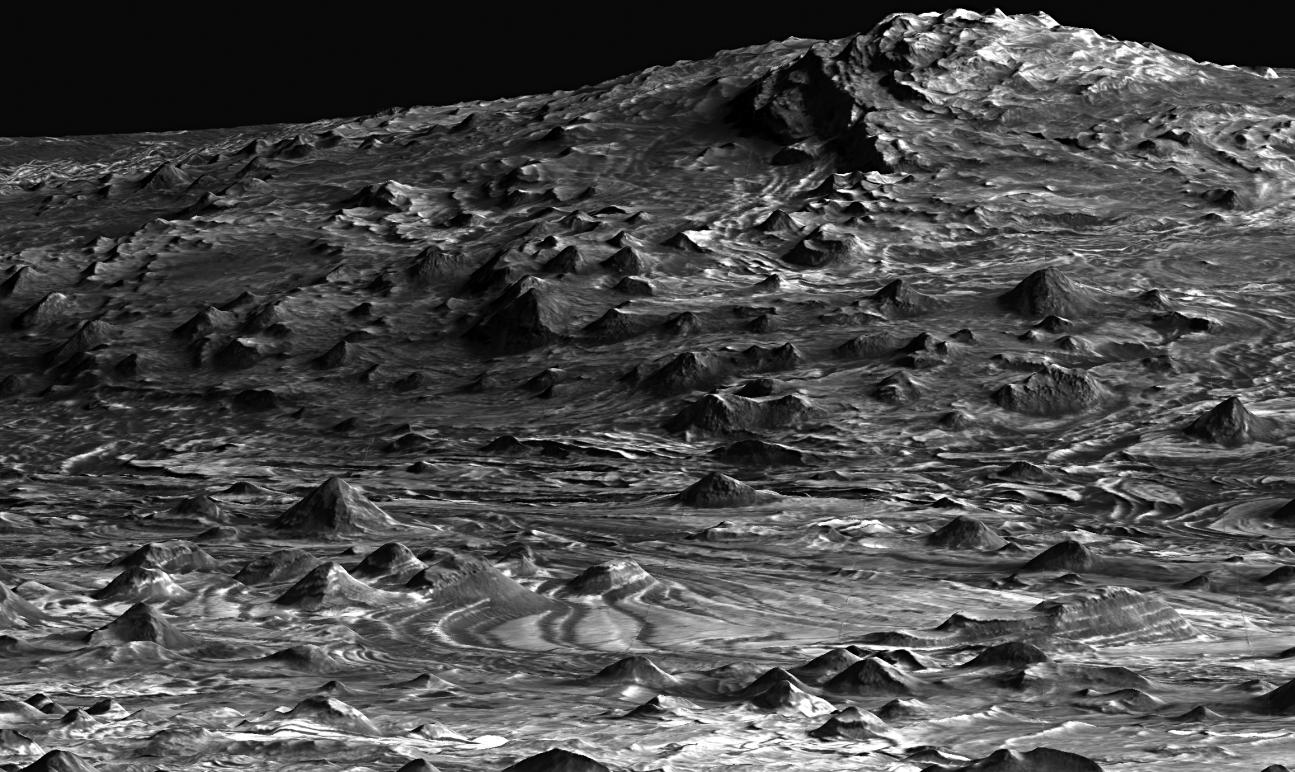
‘Low-flying’ View of Terrain in Candor Chasma
- Click the image above for a larger view
- Full-Res JPEG (2315 x 1380) (572.0 kB)
- Full-Res TIFF (2315 x 1380) (3.2 MB)
Caption:
This is a perspective view of a scene within Mars' Candor Chasma based on stereo imaging by the High Resolution Imaging Science Experiment (HiRISE) camera aboard NASA's Mars Reconnaissance Orbiter. It shows how the surface would appear from a few hundred meters or yards above the surface, as if from a low-flying airplane.
Layers of light-toned rock can be traced from the foreground up onto the hills in the background. Total vertical relief in this view is approximately 700 meters (2,200 feet). Regional views such as this help to tie together individual measurements of layer orientations and help to reveal regional patterns in the bedrock layering. These regional layer orientations provide insight into the geologic history recorded in the rocks. The dark-toned material is a surface layer of windblown sand. Width of the scene at the bottom of the image is approximately 1 kilometer (0.6 mile). There is no vertical exaggeration.
The detailed three-dimensional information of the area comes from a pair of HiRISE observations. Those full observations are available online at http://hirise.lpl.arizona.edu/PSP_003474_1735" and http://hirise.lpl.arizona.edu/PSP_003540_1735 .
Cataloging Keywords:
| Name | Value | Additional Values |
|---|---|---|
| Target | Mars | |
| System | ||
| Target Type | Planet | |
| Mission | Mars Reconnaissance Orbiter (MRO) | |
| Instrument Host | Mars Reconnaissance Orbiter | |
| Host Type | Orbiter | |
| Instrument | High Resolution Imaging Science Experiment (HiRISE) | |
| Detector | ||
| Extra Keywords | Grayscale | |
| Acquisition Date | ||
| Release Date | 2007-12-11 | |
| Date in Caption | ||
| Image Credit | NASA/JPL-Caltech/Univ. of Arizona | |
| Source | photojournal.jpl.nasa.gov/catalog/PIA10135 | |
| Identifier | PIA10135 | |