|
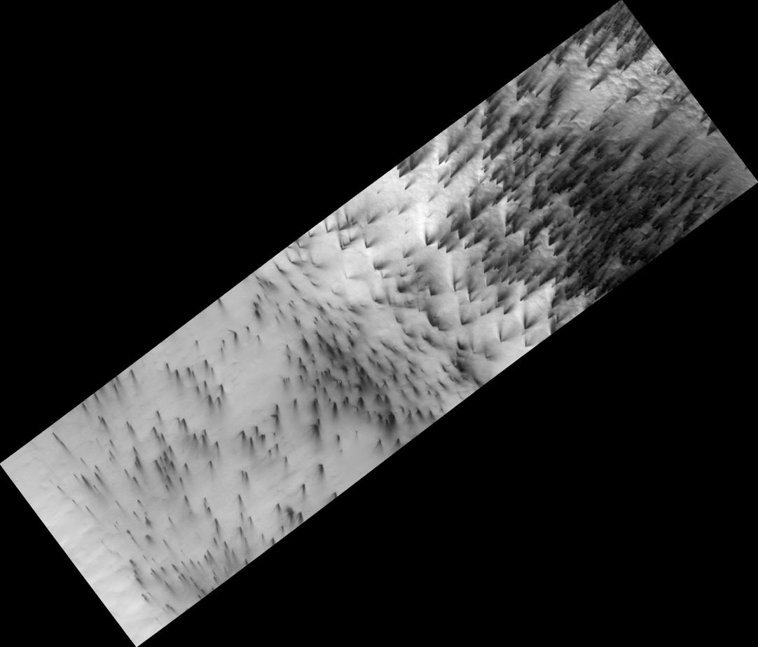
Dry Ice Etches Terrain
- Click the image above for a larger view
- Full-Res JPEG (2048 x 1747) (187.9 kB)
- Full-Res TIFF (2048 x 1747) (3.6 MB)
Caption:
Figure 1
Every year seasonal carbon dioxide ice, known to us as "dry ice," covers the poles of Mars. In the south polar region this ice is translucent, allowing sunlight to pass through and warm the surface below. The ice then sublimes (evaporates) from the bottom of the ice layer, and carves channels in the surface.
The channels take on many forms. In the subimage shown here (figure 1) the gas from the dry ice has etched wide shallow channels. This region is relatively flat, which may be the reason these channels have a different morphology than the "spiders" seen in more hummocky terrain.
Observation Geometry
Image
PSP_003364_0945
was taken by the High Resolution Imaging Science Experiment (HiRISE) camera onboard the Mars Reconnaissance Orbiter spacecraft on 15-Apr-2007. The complete image is centered at -85.4 degrees latitude, 104.0 degrees East longitude. The range to the target site was 251.5 km (157.2 miles). At this distance the image scale is 25.2 cm/pixel (with 1 x 1 binning) so objects ~75 cm across are resolved. The image shown here has been map-projected to 25 cm/pixel . The image was taken at a local Mars time of 06:57 PM and the scene is illuminated from the west with a solar incidence angle of 75 degrees, thus the sun was about 15 degrees above the horizon. At a solar longitude of 219.6 degrees, the season on Mars is Northern Autumn.
Background Info:
NASA's Jet Propulsion Laboratory, a division of the California Institute of Technology in Pasadena, manages the Mars Reconnaissance Orbiter for NASA's Science Mission Directorate, Washington. Lockheed Martin Space Systems, Denver, is the prime contractor for the project and built the spacecraft. The High Resolution Imaging Science Experiment is operated by the University of Arizona, Tucson, and the instrument was built by Ball Aerospace and Technology Corp., Boulder, Colo.
Cataloging Keywords:
| Name | Value | Additional Values |
|---|---|---|
| Target | Mars | |
| System | ||
| Target Type | Planet | |
| Mission | Mars Reconnaissance Orbiter (MRO) | |
| Instrument Host | Mars Reconnaissance Orbiter | |
| Host Type | Orbiter | |
| Instrument | High Resolution Imaging Science Experiment (HiRISE) | |
| Detector | ||
| Extra Keywords | Grayscale, Map | |
| Acquisition Date | ||
| Release Date | 2007-12-11 | |
| Date in Caption | ||
| Image Credit | NASA/JPL-Caltech/University of Arizona | |
| Source | photojournal.jpl.nasa.gov/catalog/PIA10146 | |
| Identifier | PIA10146 | |