
|
CRISM’s Global Mapping of Mars, Part 3
- Click the image above for a larger view
- Full-Res JPEG (1350 x 1380) (425.2 kB)
- Full-Res TIFF (1350 x 1380) (5.6 MB)
Caption:
After a year in Mars orbit, CRISM has taken enough images to allow the team to release the first parts of a global spectral map of Mars to the Planetary Data System (PDS), NASA's digital library of planetary data.
CRISM's global mapping is called the "multispectral survey." The team uses the word "survey" because a reason for gathering this data set is to search for new sites for targeted observations, high-resolution views of the surface at 18 meters per pixel in 544 colors. Another reason for the multispectral survey is to provide contextual information. Targeted observations have such a large data volume (about 200 megabytes apiece) that only about 1% of Mars can be imaged at CRISM's highest resolution. The multispectral survey is a lower data volume type of observation that fills in the gaps between targeted observations, allowing scientists to better understand their geologic context.
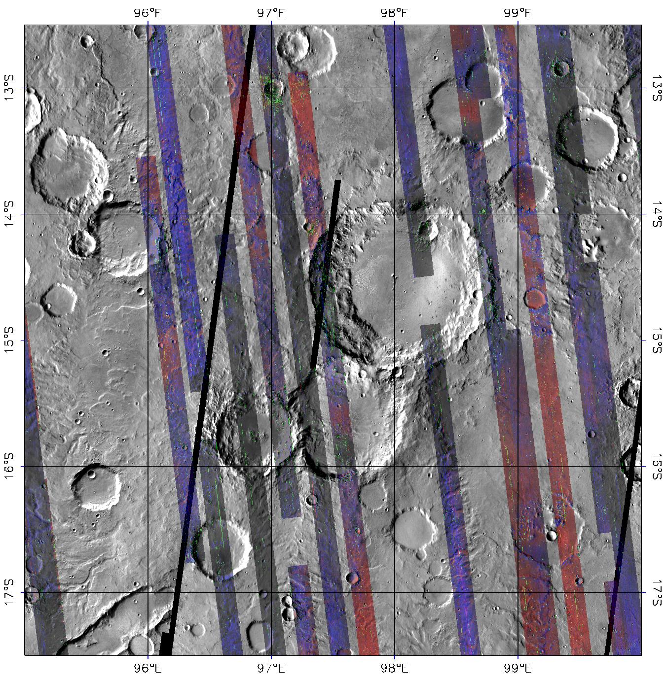
The global map is built from tens of thousands of image strips each about 10 kilometers (6.2 miles) wide and thousands of kilometers long. During the multispectral survey, CRISM returns data from only 72 carefully selected wavelengths that cover absorptions indicative of the mineral groups that CRISM is looking for on Mars. Data volume is further decreased by binning image pixels inside the instrument to a scale of about 200 meters (660 feet) per pixel. The total reduction in data volume per square kilometer is a factor of 700, making the multispectral survey manageable to acquire and transmit to Earth. Once on the ground, the strips of data are mosaicked into maps. The multispectral survey is too large to show the whole planet in a single map, so the map is divided into 1,964 "tiles," each about 300 kilometers (186 miles) across. There are three versions of each tile, processed to progressively greater levels to strip away the obscuring effects of the dusty atmosphere and to highlight mineral variations in surface materials.
This is the third and most processed version of tile 750, showing a part of Mars called Tyrrhena Terra in the ancient, heavily cratered highlands. The colored strips are CRISM multispectral survey data acquired over several months, in which each pixel began as calibrated 72-color spectrum of Mars. An experimental correction for illumination and atmospheric effects was applied to the data, to show how Mars' surface would appear if each strip was imaged with the same illumination and without an atmosphere. Then, the spectrum for each pixel was transformed into a set of "summary parameters," which indicate absorptions showing the presence of different minerals. Detections of the igneous, iron-bearing minerals olivine and pyroxene are shown in the red and blue image planes, respectively. Clay-like minerals called phyllosilicates, which formed when liquid water altered the igneous rocks, are shown in the green image plane. The gray areas between the strips are from an earlier mosaic of the planet taken by the Thermal Emission Imaging System (THEMIS) instrument on Mars Odyssey, and are included for context. Note that most areas imaged by CRISM contain pyroxene, and that olivine-containing rocks are concentrated on smooth deposits that fill some crater floors and the low areas between craters. Phyllosilicate-containing rocks are concentrated in and around small craters, such as the one at 13 degrees south latitude, 97 degrees east longitude. Their concentration in crater materials suggests that they were excavated when the craters formed, from a layer that was buried by the younger, less altered, olivine- and pyroxene-containing rocks.
Background Info:
CRISM is one of six science instruments on NASA's Mars Reconnaissance Orbiter. Led by The Johns Hopkins University Applied Physics Laboratory, Laurel, Md., the CRISM team includes expertise from universities, government agencies and small businesses in the United States and abroad. NASA's Jet Propulsion Laboratory, a division of the California Institute of Technology in Pasadena, manages the Mars Reconnaissance Orbiter and the Mars Science Laboratory for NASA's Science Mission Directorate, Washington. Lockheed Martin Space Systems, Denver, built the orbiter.
Cataloging Keywords:
| Name | Value | Additional Values |
|---|---|---|
| Target | Mars | |
| System | ||
| Target Type | Planet | |
| Mission | Mars Reconnaissance Orbiter (MRO) | 2001 Mars Odyssey, Mars Science Laboratory (MSL) |
| Instrument Host | Mars Reconnaissance Orbiter | Curiosity Rover, Mars Odyssey |
| Host Type | Orbiter | Rover |
| Instrument | Compact Reconnaissance Imaging Spectrometer for Mars (CRISM) | |
| Detector | ||
| Extra Keywords | Atmosphere, Color, Crater, Dust, Map, Thermal, Water | |
| Acquisition Date | ||
| Release Date | 2007-12-12 | |
| Date in Caption | ||
| Image Credit | NASA/JPL/JHUAPL/Applied Coherent Technology | |
| Source | photojournal.jpl.nasa.gov/catalog/PIA10203 | |
| Identifier | PIA10203 | |