|
Topographic Map of Titan’s North Polar Region
- Click the image above for a larger view
- Full-Res JPEG (2800 x 700) (292.4 kB)
- Full-Res TIFF (2800 x 700) (5.9 MB)
Caption:
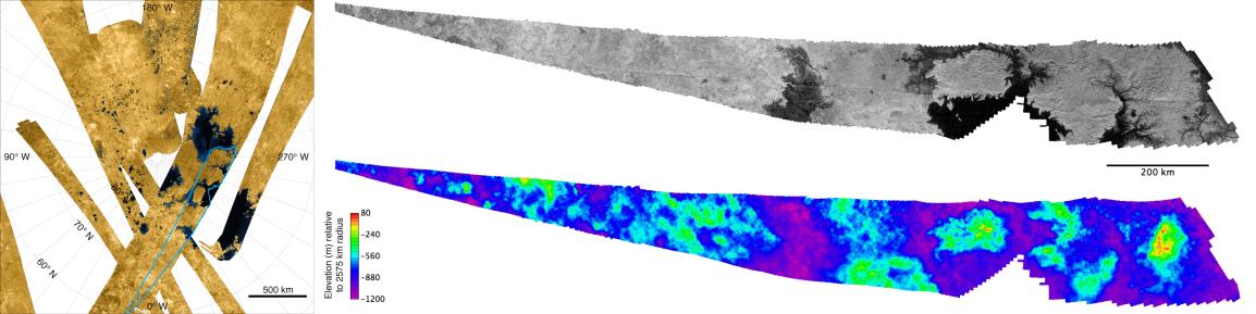
The image is the first topographic map of part of Titan's north polar region.
The false-color mosaic on the left was produced from overlapping stereo images from the Cassini radar instrument and depicts Titan's north polar region including several of its largest "seas." The mosaic (see PIA10008 for a larger version) has been false-colored to emphasize the contrast between radar-dark areas believed to be lakes and seas (shown in blue and black) and the relatively radar-bright dry land areas (shown in shades of brown). The material filling the dark areas is most likely a mixture of liquid methane, ethane and dissolved nitrogen.
The two "knife-shaped" images to the right are actually blowups of a region in the mosaic of radar images outlined in blue. This region is 1,700 by 200 kilometers (1,050 by 125 miles) in area.
The upper right insert depicts the synthetic aperture radar image obtained during Cassini's April 11, 2007, flyby. It shows multiple dark estuaries including a large island in the eastern half. Extensive dendritic (branching) systems of channels appear to feed into these estuaries. The western portion includes what appear to be steep-sided depressions. These have been hypothesized to be volcanic in origin, or alternatively to be the result of dissolution of surface materials by fluids.
The lower right insert is the topographic map which combined data from the April 11, 2007, flyby with that of a previous flyby on February 22 of the same year. The result clearly shows that the bright areas are high relative to the darker areas believed to be liquid filled. The elevations—indicated by color—are relative to the mean for Titan's radius of 2,575 kilometers (1,600 miles). The total range of elevations is only about 1.3 kilometers (0.8 miles), so that surface slopes are very gentle, a few degrees or less.
Background Info:
The Cassini-Huygens mission is a cooperative project of NASA, the European Space Agency and the Italian Space Agency. The Jet Propulsion Laboratory, a division of the California Institute of Technology in Pasadena, manages the mission for NASA's Science Mission Directorate, Washington, D.C. The Cassini orbiter was designed, developed and assembled at JPL. The radar instrument was built by JPL and the Italian Space Agency, working with team members from the United States and several European countries.
For more information about the Cassini-Huygens mission, visit http://saturn.jpl.nasa.gov/home/index.cfm .
Cataloging Keywords:
| Name | Value | Additional Values |
|---|---|---|
| Target | Titan | |
| System | Saturn | |
| Target Type | Satellite | |
| Mission | Cassini-Huygens | |
| Instrument Host | Cassini Orbiter | |
| Host Type | Orbiter | |
| Instrument | Radar Mapper | |
| Detector | ||
| Extra Keywords | Color, Map, Methane, Radar, Volcano | |
| Acquisition Date | ||
| Release Date | 2008-03-31 | |
| Date in Caption | 2007-04-11 | |
| Image Credit | NASA/JPL-Caltech/ASI/USGS | |
| Source | photojournal.jpl.nasa.gov/catalog/PIA10353 | |
| Identifier | PIA10353 | |