
|
First Laser Altimetry for Mercury
- Click the image above for a larger view
- Full-Res JPEG (3000 x 2025) (557.2 kB)
- Full-Res TIFF (3000 x 2025) (18.2 MB)
Caption:
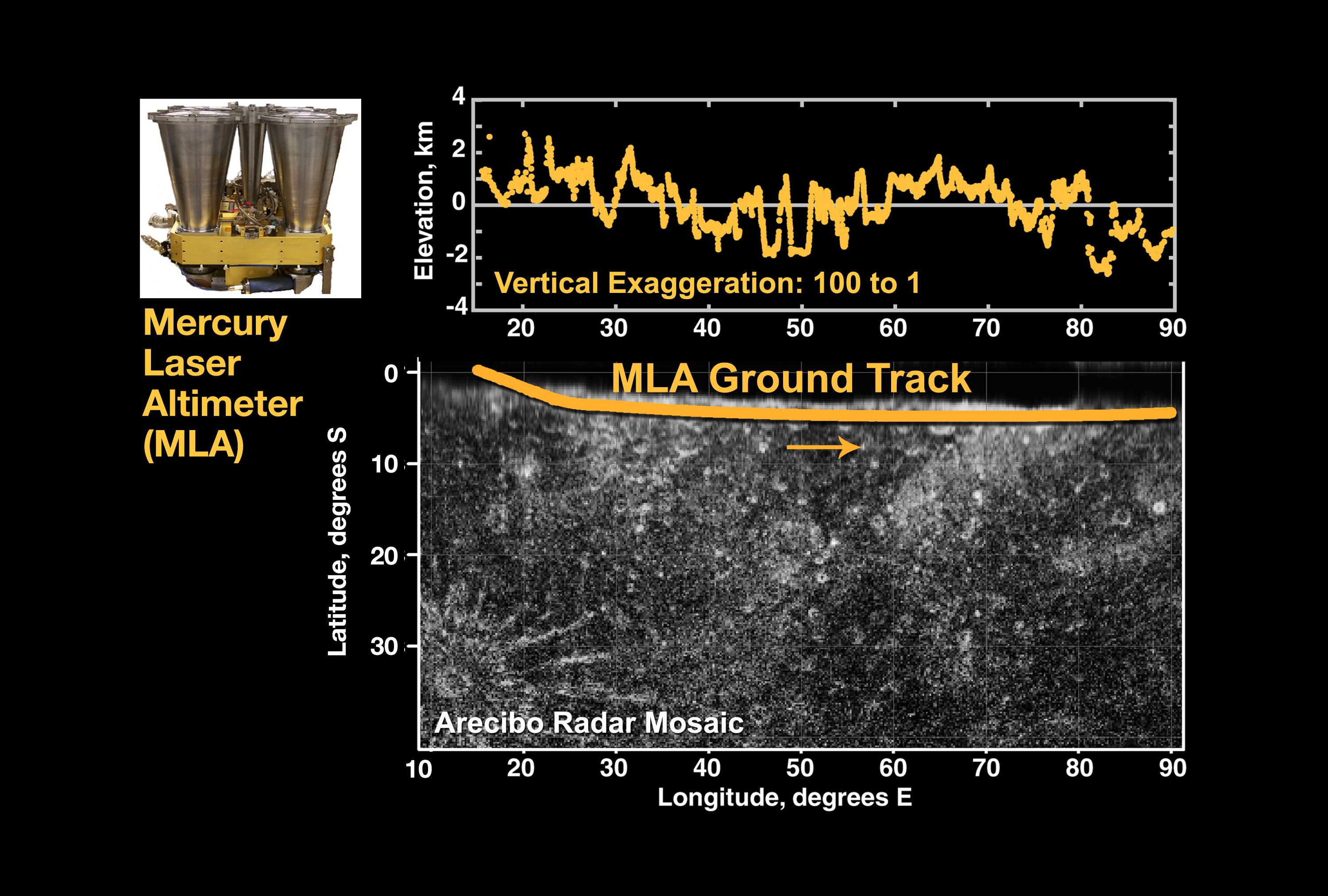
At top center is the first laser altimeter profile of Mercury's topography, taken by MESSENGER's Mercury Laser Altimeter (MLA) instrument during the spacecraft's flyby of Mercury on January 14, 2008. At bottom center is the MLA ground projected onto a mosaic of radar images obtained by Harmon and others at the Arecibo Observatory in Puerto Rico.
The interval during which MESSENGER was sufficiently close to the planet to be within measurement range of the MLA was when the spacecraft was on the night side, so there are no corresponding images of this region acquired by MESSENGER during this flyby; this region was also unseen by Mariner 10. The length of the profile is about 3200 km (about 2000 miles), and the dynamic range in elevation across the profile is about 5 km (about 3 miles). The profile sampled numerous craters and basins. The vertical exaggeration in the figure is 105:1.
At top left is a photograph of the MLA flight unit.
Background Info:
These images are from MESSENGER, a NASA Discovery mission to conduct the first orbital study of the innermost planet, Mercury. For information regarding the use of images, see the MESSENGER image use policy .
Cataloging Keywords:
| Name | Value | Additional Values |
|---|---|---|
| Target | Mercury | |
| System | ||
| Target Type | Planet | |
| Mission | MESSENGER | Mariner, National Astronomy and Ionosphere Center (NAIC) |
| Instrument Host | MESSENGER | Arecibo Observatory, Mariner 10 |
| Host Type | Orbiter | Flyby Spacecraft, Ground-Based Observatory |
| Instrument | Mercury Laser Altimeter (MLA) | Arecibo Radar |
| Detector | ||
| Extra Keywords | Color, Crater, Radar | |
| Acquisition Date | ||
| Release Date | 2008-01-30 | |
| Date in Caption | 2008-01-14 | |
| Image Credit | NASA/Goddard Space Flight Center/Cornell University/Johns Hopkins University Applied Physics Laboratory/Carnegie Institution of Washington | |
| Source | photojournal.jpl.nasa.gov/catalog/PIA10394 | |
| Identifier | PIA10394 | |