|
Livonia, New York, Students Study Past Martian Water
- Click the image above for a larger view
- Full-Res JPEG (1130 x 1490) (227.9 kB)
- Full-Res TIFF (1130 x 1490) (5.1 MB)
Caption:
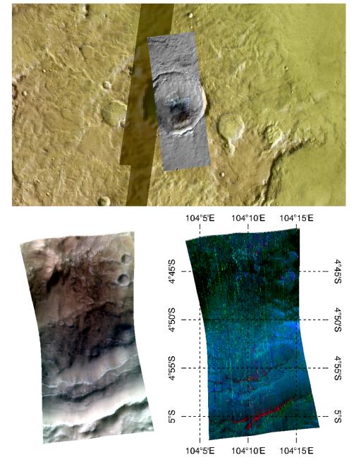
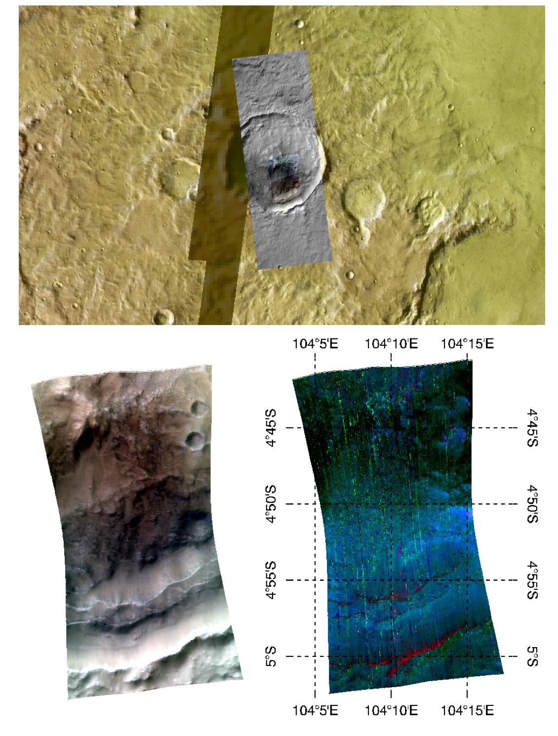
This image of the central peak and wall of a crater in Tyrrhena Terra, in Mars' ancient southern highlands, was taken by the Compact Reconnaissance Imaging Spectrometer for Mars (CRISM) at 0956 UTC (4:56 a.m. EST) on February 8, 2008, near 4.85 degrees south latitude, 104.16 degrees east longitude. CRISM's image was taken in 544 colors covering 0.36-3.92 micrometers, and shows features as small as 35 meters (115 feet) across. The region covered is just over 10 kilometers (6.2 miles) wide at its narrowest point.
This image was part of an investigation planned by students at Livonia High School in Livonia, New York. The students are working with the CRISM science team in a project called the Mars Exploration Student Data Teams (MESDT), which is part of NASA's Mars Public Engagement Program and Arizona State University's Mars Education Program. The students started by analyzing a medium-resolution map of the area, taken as part of CRISM's "multispectral survey" campaign to map Mars in 72 colors at 200 meters (660 feet) per pixel. They noted multiple outcrops of clay-like minerals called phyllosilicates in the walls and central peaks of impacts craters, and hypothesized that the craters were excavating an extremely ancient, buried rock layer that had been altered by liquid water. They chose this central peak for a closer look to test their ideas, and provided its coordinates to CRISM's operations team who took a high-resolution image of the site. The Context Imager (CTX) accompanied CRISM with a 6 meter (20 feet) per pixel, high-resolution image to sharpen the relationship of spectral variations to the underlying surface structures. The Livonia High School students worked with a mentor on the CRISM team to analyze the data, and presented their project at the 39th Lunar and Planetary Science Conference, held in League City, Texas, on March 10-14, 2008.
The upper panel of the image shows the location of the CRISM data and the surrounding, larger CTX image, overlain on an image mosaic taken by the Thermal Emission Imaging System (THEMIS) on Mars Odyssey. The mosaic has been color-coded for elevation using data from the Mars Orbiter Laser Altimeter (MOLA) instrument on the Mars Global Surveyor (MGS) spacecraft. Redder colors indicate higher elevations. The bottom left image shows infrared brightness of the surface measured by CRISM at 2.5, 1.5, and 1.1 micrometers. In the lower right image, the data have been transformed into a map of spectral features indicating the presence of different minerals. This map emphasizes the primary igneous minerals that are present, with reddish areas indicating olivine and blue to greenish areas indicating pyroxene. In a different version of the mineral map, phyllosilicates can also be seen in the crater's central peak near the upper portion of the image.
Background Info:
CRISM is one of six science instruments on NASA's Mars Reconnaissance Orbiter. Led by The Johns Hopkins University Applied Physics Laboratory, Laurel, Md., the CRISM team includes expertise from universities, government agencies and small businesses in the United States and abroad. NASA's Jet Propulsion Laboratory, a division of the California Institute of Technology in Pasadena, manages the Mars Reconnaissance Orbiter and the Mars Science Laboratory for NASA's Science Mission Directorate, Washington. Lockheed Martin Space Systems, Denver, built the orbiter.
Cataloging Keywords:
| Name | Value | Additional Values |
|---|---|---|
| Target | Mars | |
| System | ||
| Target Type | Planet | |
| Mission | Mars Reconnaissance Orbiter (MRO) | 2001 Mars Odyssey, Mars Global Surveyor (MGS), Mars Science Laboratory (MSL) |
| Instrument Host | Mars Reconnaissance Orbiter | Curiosity Rover, Mars Global Surveyor, Mars Odyssey |
| Host Type | Orbiter | Rover |
| Instrument | Compact Reconnaissance Imaging Spectrometer for Mars (CRISM) | |
| Detector | ||
| Extra Keywords | Color, Crater, Impact, Infrared, Map, Thermal, Water | |
| Acquisition Date | ||
| Release Date | 2008-03-28 | |
| Date in Caption | 2008-02-08 | |
| Image Credit | NASA/JPL/JHUAPL | |
| Source | photojournal.jpl.nasa.gov/catalog/PIA10641 | |
| Identifier | PIA10641 | |