skip to navigation

|
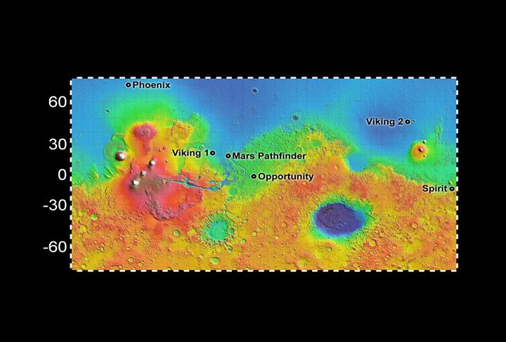
Six Landing Sites on Mars
- Click the image above for a larger view
- Full-Res JPEG (720 x 486) (44.6 kB)
- Full-Res TIFF (720 x 486) (1.1 MB)
Caption:
The landing site chosen for NASA's Phoenix Mars Lander, at about 68 degrees north latitude, is much farther north than the sites where previous spacecraft have landed on Mars.
Color coding on this map indicates relative elevations based on data from the Mars Orbiter Laser Altimeter on NASA's Mars Global Surveyor. Red is higher elevation; blue is lower elevation. In longitude, the map extends from 70 degrees (north) to minus 70 degrees (south).
Background Info:
Photojournal Note: As planned, the Phoenix lander, which landed May 25, 2008 23:53 UTC, ended communications in November 2008, about six months after landing, when its solar panels ceased operating in the dark Martian winter.
Cataloging Keywords:
| Name | Value | Additional Values |
|---|---|---|
| Target | Mars | |
| System | ||
| Target Type | Planet | |
| Mission | Mars Global Surveyor (MGS) | Phoenix |
| Instrument Host | Mars Global Surveyor | Phoenix Lander |
| Host Type | Orbiter | Lander |
| Instrument | Mars Orbiter Laser Altimeter (MOLA) | |
| Detector | ||
| Extra Keywords | Color, Map | |
| Acquisition Date | ||
| Release Date | 2008-05-22 | |
| Date in Caption | ||
| Image Credit | NASA/JPL-Caltech | |
| Source | photojournal.jpl.nasa.gov/catalog/PIA10656 | |
| Identifier | PIA10656 | |