
|
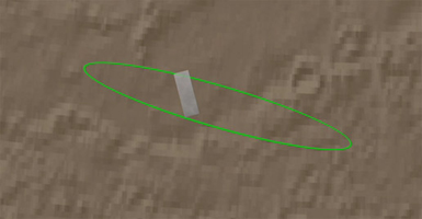
Zooming in on Landing Site
- Click the image above for a larger view
 Movie Download Options
- Full-Res JPEG (516 x 268) (11.5 kB)
- Full-Res TIFF (516 x 268) (415.5 kB)
Caption:
Click on the image for movie of
Zooming in on Landing Site
This animation zooms in on the area on Mars where NASA's Phoenix Mars Lander will touchdown on May 25, 2008. The image was taken by the High Resolution Imaging Science Experiment (HiRISE) camera on NASA's Mars Reconnaissance Orbiter.
The first shot shows the spacecraft's landing ellipse in green, the area where Phoenix has a high probability of landing. It then zooms in to show the region's arctic terrain. This polar landscape is relatively free of rocks, with only about 1 to 2 rocks 1.5 meters (4.9 feet) or larger in an area about as big as two football fields.
Background Info:
NASA's Jet Propulsion Laboratory, a division of the California Institute of Technology in Pasadena, manages the Mars Reconnaissance Orbiter for NASA's Science Mission Directorate, Washington. Lockheed Martin Space Systems, Denver, is the prime contractor for the project and built the spacecraft. The High Resolution Imaging Science Experiment is operated by the University of Arizona, Tucson, and the instrument was built by Ball Aerospace & Technologies Corp., Boulder, Colo.
Photojournal Note: As planned, the Phoenix lander, which landed May 25, 2008 23:53 UTC, ended communications in November 2008, about six months after landing, when its solar panels ceased operating in the dark Martian winter.
Cataloging Keywords:
| Name | Value | Additional Values |
|---|---|---|
| Target | Mars | |
| System | ||
| Target Type | Planet | |
| Mission | Mars Reconnaissance Orbiter (MRO) | Phoenix |
| Instrument Host | Mars Reconnaissance Orbiter | Phoenix Lander |
| Host Type | Orbiter | Lander |
| Instrument | High Resolution Imaging Science Experiment (HiRISE) | |
| Detector | ||
| Extra Keywords | Color, Movie | |
| Acquisition Date | ||
| Release Date | 2008-05-24 | |
| Date in Caption | 2008-05-25 | |
| Image Credit | NASA/JPL-Caltech/University of Arizona | |
| Source | photojournal.jpl.nasa.gov/catalog/PIA10669 | |
| Identifier | PIA10669 | |