|
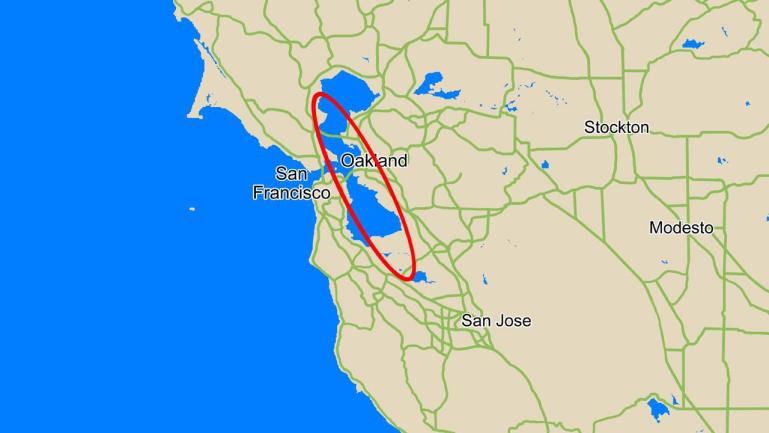
Phoenix Landing Ellipse Over San Francisco
- Click the image above for a larger view
- Full-Res JPEG (1280 x 720) (76.4 kB)
- Full-Res TIFF (1280 x 720) (2.8 MB)
Caption:
This map compares the size of the area where NASA's Phoenix Mars Lander is expected to land, called the landing ellipse (red), to the size of the San Francisco Bay Area.
Phoenix has a 99.9 percent probability of landing within the area denoted by its landing ellipse, a region in the northern plains of Mars centered at approximately 68 degrees north latitude, 233 degrees east longitude. The ellipse is about 70 kilometers (44 miles) long. Phoenix is most likely to land near the center of the ellipse, and least likely to land at its very edges.
Background Info:
The Phoenix Mission is led by the University of Arizona, Tucson, on behalf of NASA. Project management of the mission is by NASA's Jet Propulsion Laboratory, Pasadena, Calif. Spacecraft development is by Lockheed Martin Space Systems, Denver.
Photojournal Note: As planned, the Phoenix lander, which landed May 25, 2008 23:53 UTC, ended communications in November 2008, about six months after landing, when its solar panels ceased operating in the dark Martian winter.
Cataloging Keywords:
| Name | Value | Additional Values |
|---|---|---|
| Target | Mars | |
| System | ||
| Target Type | Planet | |
| Mission | Phoenix | |
| Instrument Host | Phoenix Lander | |
| Host Type | Lander | |
| Instrument | ||
| Detector | ||
| Extra Keywords | Color, Map | |
| Acquisition Date | ||
| Release Date | 2008-05-24 | |
| Date in Caption | ||
| Image Credit | NASA/JPL-Caltech/University of Arizona | |
| Source | photojournal.jpl.nasa.gov/catalog/PIA10675 | |
| Identifier | PIA10675 | |