|
Phoenix’s New Neighborhood
- Click the image above for a larger view
- Full-Res JPEG (1464 x 1170) (200.9 kB)
- Full-Res TIFF (1464 x 1170) (5.1 MB)
Caption:
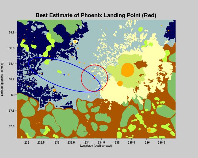
The center of the red circle on this map shows where NASA's Phoenix Mars Lander eased down to the surface of Mars, at approximately 68 degrees north latitude, 234 degrees east longitude. Before Phoenix landed, engineers had predicted it would land within the blue ellipse.
Phoenix touched down on the Red Planet at 4:53 p.m. Pacific Time (7:53 p.m. Eastern Time), May 25, 2008, in an arctic region called Vastitas Borealis.
The map shows a color-coded interpretation of geomorphic units—categories based on the surface textures and contours. The geomorphic mapping is overlaid on a shaded relief map based on data from the Mars Orbiter Laser Altimeter on NASA's Mars Global Surveyor orbiter.
Background Info:
The Phoenix Mission is led by the University of Arizona, Tucson, on behalf of NASA. Project management of the mission is by NASA's Jet Propulsion Laboratory, Pasadena, Calif. Spacecraft development is by Lockheed Martin Space Systems, Denver.
Photojournal Note: As planned, the Phoenix lander, which landed May 25, 2008 23:53 UTC, ended communications in November 2008, about six months after landing, when its solar panels ceased operating in the dark Martian winter.
Cataloging Keywords:
| Name | Value | Additional Values |
|---|---|---|
| Target | Mars | |
| System | ||
| Target Type | Planet | |
| Mission | Phoenix | Mars Global Surveyor (MGS) |
| Instrument Host | Phoenix Lander | Mars Global Surveyor |
| Host Type | Lander | Orbiter |
| Instrument | ||
| Detector | ||
| Extra Keywords | Color, Map | |
| Acquisition Date | ||
| Release Date | 2008-05-26 | |
| Date in Caption | 2008-05-25 | |
| Image Credit | NASA/JPL-Caltech/Washington Univ. St. Louis/JHUAPL/Univ. of Arizona | |
| Source | photojournal.jpl.nasa.gov/catalog/PIA10687 | |
| Identifier | PIA10687 | |