
|
Phoenix’s Position on Mars
- Click the image above for a larger view
 Movie Download Options
- Full-Res JPEG (640 x 360) (12.1 kB)
- Full-Res TIFF (640 x 360) (692.2 kB)
Caption:
Click on the image for the animation
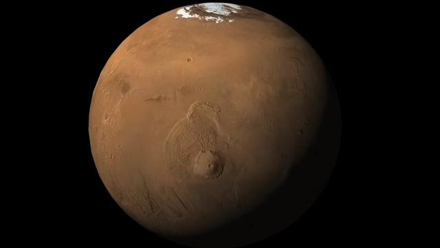
This animation shows an orbital view sweeping upward from Olympus Mons, the tallest volcano in the solar system, to the location of NASA's Phoenix Mars Lander in the northern polar reaches of Mars. The animation then zooms in on the flat terrain where Phoenix touched down May 25, 2008.
Phoenix eased down to the surface of Mars at approximately 68 degrees north latitude, 234 degrees east longitude, landing in the center of the red circle at the end of the animation. Before Phoenix landed, engineers had predicted it would land within the blue ellipse.
Phoenix touched down on the Red Planet at 4:53 p.m. Pacific Time (7:53 p.m. Eastern Time), May 25, 2008, in an arctic region called Vastitas Borealis.
The shaded relief map is based on data from the Mars Orbiter Laser Altimeter on NASA's Mars Global Surveyor orbiter.
Background Info:
The Phoenix Mission is led by the University of Arizona, Tucson, on behalf of NASA. Project management of the mission is by NASA's Jet Propulsion Laboratory, Pasadena, Calif. Spacecraft development is by Lockheed Martin Space Systems, Denver.
Photojournal Note: As planned, the Phoenix lander, which landed May 25, 2008 23:53 UTC, ended communications in November 2008, about six months after landing, when its solar panels ceased operating in the dark Martian winter.
Cataloging Keywords:
| Name | Value | Additional Values |
|---|---|---|
| Target | Mars | |
| System | ||
| Target Type | Planet | |
| Mission | Phoenix | Mars Global Surveyor (MGS) |
| Instrument Host | Phoenix Lander | Mars Global Surveyor |
| Host Type | Lander | Orbiter |
| Instrument | Mars Orbiter Laser Altimeter (MOLA) | Solid-State Imaging (SSI) |
| Detector | ||
| Extra Keywords | Color, Map, Mountain, Movie, Volcano | |
| Acquisition Date | ||
| Release Date | 2008-05-26 | |
| Date in Caption | 2008-05-25 | |
| Image Credit | NASA/JPL-Caltech/University of Arizona | |
| Source | photojournal.jpl.nasa.gov/catalog/PIA10694 | |
| Identifier | PIA10694 | |