
|
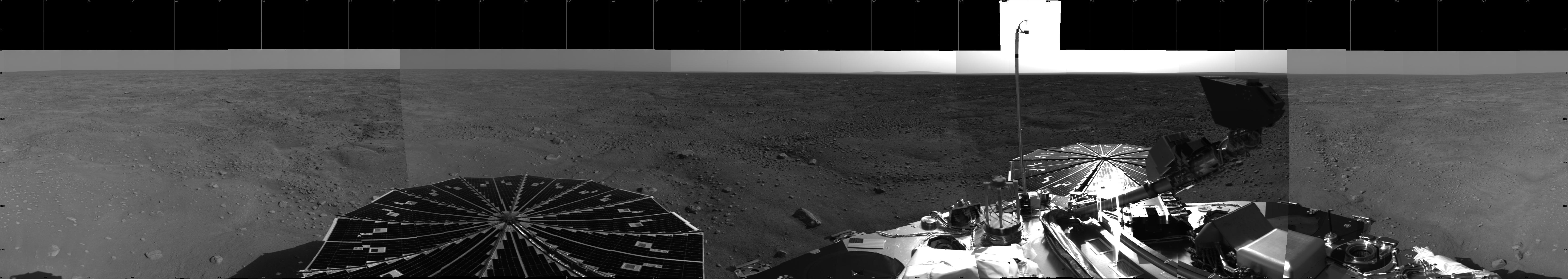
Sweeping Martian Plains
- Click the image above for a larger view
- Full-Res JPEG (6659 x 1187) (731.5 kB)
- Full-Res TIFF (6659 x 1187) (7.9 MB)
Caption:
This 360-degree view from NASA's Phoenix Mars Lander shows the spacecraft's solar arrays, lander deck and the Martian polar landscape beyond. The hummocky terrain has a network of troughs and very few rocks, typical of polar surfaces here on Earth.
Phoenix's Surface Stereo Imager captured the images making up this mosaic on the first and third martian days, or sols, of the mission (May 26 and 28, 2008). The spacecraft is capable of taking color, high-resolution photos, but its first priority is to scan its surroundings with black-and-white, lower-resolution images like these.
Background Info:
The Phoenix Mission is led by the University of Arizona, Tucson, on behalf of NASA. Project management of the mission is by NASA's Jet Propulsion Laboratory, Pasadena, Calif. Spacecraft development is by Lockheed Martin Space Systems, Denver.
Photojournal Note: As planned, the Phoenix lander, which landed May 25, 2008 23:53 UTC, ended communications in November 2008, about six months after landing, when its solar panels ceased operating in the dark Martian winter.
Cataloging Keywords:
| Name | Value | Additional Values |
|---|---|---|
| Target | Mars | |
| System | ||
| Target Type | Planet | |
| Mission | Phoenix | |
| Instrument Host | Phoenix Lander | |
| Host Type | Lander | |
| Instrument | Solid-State Imaging (SSI) | |
| Detector | ||
| Extra Keywords | Grayscale | |
| Acquisition Date | ||
| Release Date | 2008-05-29 | |
| Date in Caption | ||
| Image Credit | NASA/JPL-Caltech/Unviersity of Arizona | |
| Source | photojournal.jpl.nasa.gov/catalog/PIA10726 | |
| Identifier | PIA10726 | |