|
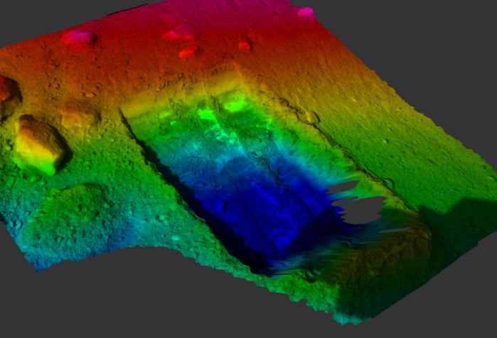
“Dodo-Goldilocks” Trench Elevation Map
- Click the image above for a larger view
- Full-Res JPEG (1266 x 863) (116.1 kB)
- Full-Res TIFF (1266 x 863) (3.3 MB)
Caption:
This color-coded elevation map shows the "Dodo-Goldilocks" trench dug by the Robotic Arm on NASA's Phoenix Mars Lander. The trench, originally two separate trenches nicknamed "Dodo" (left) and "Goldilocks" (right), became one after further digging on the 18th Martian day, or Sol 18, of the mission (June 12, 2008). The trench is 7 to 8 centimeters (2.7 to 3 inches) at its deepest (blue). Because the terrain itself is inclined at a 14-degree angle, the highest areas (pink) are about 20 centimeters (7.8 inches) above the lowest areas.
The trench is 22 centimeters (8.7 inches) wide and 35 centimeters (13.8 inches) long. Its deepest portion is closest to the lander.
This picture was taken by Phoenix's Surface Stereo Imager on Sol 19 (June 13, 2008).
Background Info:
The Phoenix Mission is led by the University of Arizona, Tucson, on behalf of NASA. Project management of the mission is by NASA's Jet Propulsion Laboratory, Pasadena, Calif. Spacecraft development is by Lockheed Martin Space Systems, Denver.
Photojournal Note: As planned, the Phoenix lander, which landed May 25, 2008 23:53 UTC, ended communications in November 2008, about six months after landing, when its solar panels ceased operating in the dark Martian winter.
Cataloging Keywords:
| Name | Value | Additional Values |
|---|---|---|
| Target | Mars | |
| System | ||
| Target Type | Planet | |
| Mission | Phoenix | |
| Instrument Host | Phoenix Lander | |
| Host Type | Lander | |
| Instrument | Robotic Arm | Solid-State Imaging (SSI) |
| Detector | ||
| Extra Keywords | Color, Map | |
| Acquisition Date | ||
| Release Date | 2008-06-16 | |
| Date in Caption | 2008-06-12 | 2008-06-13 |
| Image Credit | NASA/JPL-Caltech/University of Arizona/Texas A&M University/NASA Ames Research Center | |
| Source | photojournal.jpl.nasa.gov/catalog/PIA10904 | |
| Identifier | PIA10904 | |