|
Mawrth Vallis Phyllosilicates
- Click the image above for a larger view
- Full-Res JPEG (1684 x 1552) (381.5 kB)
- Full-Res TIFF (1684 x 1552) (7.9 MB)
Caption:
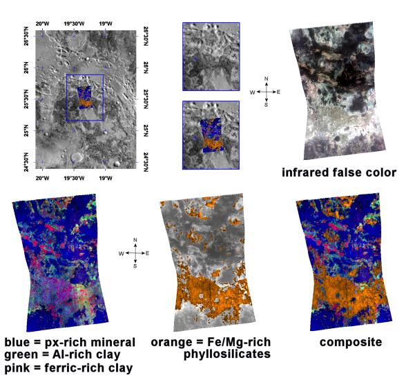
This image of phyllosilicates in Mawrth Vallis was taken by the Compact Reconnaissance Imaging Spectrometer for Mars (CRISM) at 1217 UTC (7:17 a.m. EST) on January 10, 2006, near 25.5 degrees north latitude, 19.3 degrees west longitude. CRISM's image was taken in 544 colors covering 0.36-3.92 micrometers, and shows features as small as 20 meters (66 feet) across. The region covered is roughly 12 kilometers (7.5 miles) wide at its narrowest point.
Mawrth Vallis is located to the south of Acidalia Planitia and to the east of Tiu Valles. One of the oldest channels on Mars, Mawrth Vallis cuts through the ancient cratered terrain of western Arabia Terra and is part of the Chryse Planitia basin.
Mawrth Vallis holds special interest to scientist studying Mars. In 2005 the OMEGA spectrometer on board the European Space Agency's Mars Express orbiter discovered phyllosilicates in Mawrth Vallis. Phyllosilicates are a family of hydroxyl (OH) bearing minerals that generally have a flaky or sheet-like structure. These OH-bearing minerals are often the products of water-related chemical alteration, making them good indicators for the presence of liquid water. Clay minerals are part of this family.
OMEGA's discovery made Mawrth Vallis a prime target for CRISM's higher-resolution instrumentation. The upper left panel in the montage above reveals the location of the CRISM image on a mosaic taken by the Mars Odyssey spacecraft's Thermal Emission Imaging System (THEMIS). The gray-scale THEMIS image reveals a variety of light and dark materials shaped by erosion.
The upper right image is an infrared false-color image taken by CRISM. It reveals the complex, layered nature of these deposits, while the lower three spectral images provide further detail of the region's distinct mineral layers.
The lower left image reveals two discrete clay units as well as an overlying layer of the material rich in the volcanic mineral pyroxene. The bottom-center image reveals the location of ferromagnesian (iron- and magnesium-rich) phyllosilicates superimposed on a grayscale version of the infrared image. The lower right image is a composite that combines the two previous spectral images.
Each of these distinct layers offers a clue to the planet's geologic past. The orange, ferromagnesian phyllosilicate layer corresponds to lighter material running across the lower portion of the infrared image (top right). Mars Orbiter Laser Altimeter topography reveals this area to be the lowest-elevation part of the CRISM image.
Pink areas in the both the infrared and spectral images correspond to a ferric (Fe 3+ ) clay layer, while light blue regions in the infrared image correspond to an aluminum-rich clay denoted in green on the spectral image. On Earth, such aluminum- and ferric-rich clays are often formed through the weathering or breakdown of volcanic rocks as they interact with water. The uppermost, blue, pyroxene-rich layer corresponds to darker regions in the infrared image.
Background Info:
CRISM is one of six science instruments on NASA's Mars Reconnaissance Orbiter. Led by The Johns Hopkins University Applied Physics Laboratory, Laurel, Md., the CRISM team includes expertise from universities, government agencies and small businesses in the United States and abroad. NASA's Jet Propulsion Laboratory, a division of the California Institute of Technology in Pasadena, manages the Mars Reconnaissance Orbiter and the Mars Science Laboratory for NASA's Science Mission Directorate, Washington. Lockheed Martin Space Systems, Denver, built the orbiter.
Cataloging Keywords:
| Name | Value | Additional Values |
|---|---|---|
| Target | Mars | |
| System | ||
| Target Type | Planet | |
| Mission | Mars Reconnaissance Orbiter (MRO) | 2001 Mars Odyssey, Mars Express, Mars Express (MEX), Mars Science Laboratory (MSL) |
| Instrument Host | Mars Reconnaissance Orbiter | Curiosity Rover, Mars Express, Mars Express Orbiter, Mars Odyssey |
| Host Type | Orbiter | Rover |
| Instrument | Compact Reconnaissance Imaging Spectrometer for Mars (CRISM) | Visible and Infrared Mineralogical Mapping Spectrometer (OMEGA) |
| Detector | ||
| Extra Keywords | Color, Crater, Infrared, Thermal, Volcano, Water | |
| Acquisition Date | ||
| Release Date | 2008-05-15 | |
| Date in Caption | 2006-01-10 | |
| Image Credit | NASA/JPL/JHUAPL/ASU | |
| Source | photojournal.jpl.nasa.gov/catalog/PIA10944 | |
| Identifier | PIA10944 | |