|
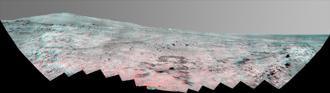
Southern Half of Spirit’s ‘Bonestell’ Panorama (Anaglyph)
- Click the image above for a larger view
- Full-Res JPEG (12221 x 3471) (4.4 MB)
- Full-Res TIFF (12221 x 3471) (127.3 MB)
Caption:
This stereo, 180-degree panorama shows the southward vista from the location where Spirit is spending its third Martian winter inside Mars' Gusev Crater. The rover's overwintering location is on the northern edge of a low plateau informally called "Home Plate," which is about 80 meters or 260 feet in diameter.
The view combines a stereo pair so that it appears three-dimensional when seen through blue-red glasses.
Spirit took the first of the images that are combined into this view during the mission's 1,477th Martian day, or sol, (February 28, 2008) two weeks after the rover made its last move to reach the location where it would stop driving for the winter. Solar energy at Gusev Crater is so limited during the Martian winter that Spirit does not generate enough electricity to drive, nor even enough to take many images per day. The last frame for this mosaic was taken on Sol 1599 (July 2, 2008). The rover team plans for Spirit to finish taking images for the northern half of the scene during the Martian spring.
The northwestern edge of Home Plate is visible in the right foreground. The blockier, more sharply shadowed texture there is layered sandstone whose layering is tilted inward toward the edge of the Home Plate platform. A dark rock on top of Home Plate in that area is a porous volcanic basalt unlike rocks nearby. The northeastern edge of Home Plate is visible in the left foreground. Spirit first climbed onto Home Plate on that region, in early 2006.
Rover tracks from driving by Spirit are visible on Home plate in the center and right of the image. These were made during Spirit's second exploration on top of the plateau, which began when Spirit climbed onto the southern edge of Home Plate in September, 2007.
In the center foreground, the turret of tools at the end of Spirit's robotic arm appears in duplicate because the arm was repositioned between the days when the images making up that part of the mosaic were taken.
On the horizon, the highest point is "McCool Hill." This is one of the seven larger hills in the Columbia Hills range. Home Plate is in the inner basin of the range, between McCool Hill to the south and "Husband Hill" to the north. To the right of McCool Hill, in the center of the image and closer to Home Plate, is a smaller hill capped with a light-toned outcrop. This hill is called "Von Braun," and it is a possible destination the rover team has discussed for the next season of driving by Spirit, after the solar energy level increases in the Martian spring. The flat horizon in the right-hand portion of the panorama is the basaltic plain onto which Spirit landed on Jan. 4, 2004.
Cataloging Keywords:
| Name | Value | Additional Values |
|---|---|---|
| Target | Mars | |
| System | ||
| Target Type | Planet | |
| Mission | Mars Exploration Rover (MER) | |
| Instrument Host | Spirit (MER-A) | |
| Host Type | Rover | |
| Instrument | Panoramic Camera (Pancam) | |
| Detector | ||
| Extra Keywords | Color, Crater, Shadow, Volcano | |
| Acquisition Date | ||
| Release Date | 2008-08-26 | |
| Date in Caption | 2004-01-04 | 2008-02-28, 2008-07-02 |
| Image Credit | NASA/JPL/Cornell | |
| Source | photojournal.jpl.nasa.gov/catalog/PIA11050 | |
| Identifier | PIA11050 | |