
|
Filling the Gaps
- Click the image above for a larger view
- Full-Res JPEG (1800 x 992) (287.0 kB)
- Full-Res TIFF (1800 x 992) (1.8 MB)
Caption:
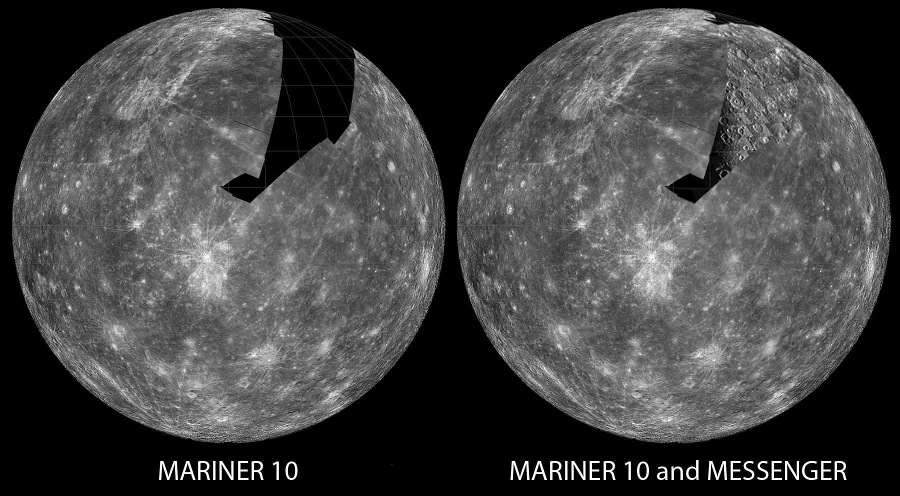
In the 1970s, the Mariner 10 spacecraft flew by Mercury three times, imaging nearly all of one hemisphere (45% of the planet). Due to the geometry of the flybys, a large swath of terrain in the northern portion of that hemisphere was never seen (left image), until October 6, 2008, when the MESSENGER spacecraft flew by the planet for the second time, revealing this ancient cratered terrain (right image). Filling in this gap allows scientists to use both Mariner 10 and MESSENGER data to better characterize the various processes that shaped the surface of Mercury over time. ( View images taken by Mariner 10. )
Date Acquired:
October 6, 2008
Image Mission Elapsed Time (MET):
131771118 to 131772268
Instrument:
Narrow Angle Camera (NAC) of the Mercury Dual Imaging System (MDIS)
Scale:
Mercury's diameter is 4880 kilometers (3030 miles)
Spacecraft Altitude:
5,000-11,000 kilometers (3,000-6,900 miles)
Background Info:
These images are from MESSENGER, a NASA Discovery mission to conduct the first orbital study of the innermost planet, Mercury. For information regarding the use of images, see the MESSENGER image use policy .
Cataloging Keywords:
| Name | Value | Additional Values |
|---|---|---|
| Target | Mercury | |
| System | ||
| Target Type | Planet | |
| Mission | MESSENGER | Mariner |
| Instrument Host | MESSENGER | Mariner 10 |
| Host Type | Orbiter | Flyby Spacecraft |
| Instrument | Mercury Dual Imaging System (MDIS) | Imaging Science Subsystem (ISS) |
| Detector | Narrow Angle Camera (NAC) | |
| Extra Keywords | Crater, Grayscale | |
| Acquisition Date | ||
| Release Date | 2008-10-08 | |
| Date in Caption | 2008-10-06 | |
| Image Credit | NASA/Johns Hopkins University Applied Physics Laboratory/Carnegie Institution of Washington | |
| Source | photojournal.jpl.nasa.gov/catalog/PIA11354 | |
| Identifier | PIA11354 | |