|
A New Look at Old Terrain
- Click the image above for a larger view
- Full-Res JPEG (2000 x 1005) (256.4 kB)
- Full-Res TIFF (2000 x 1005) (2.0 MB)
Caption:
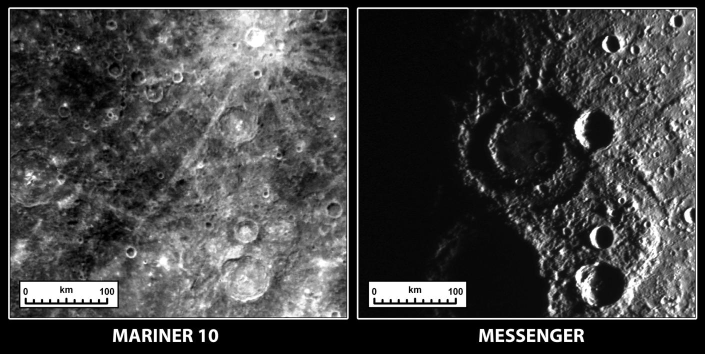
These two images show the same terrain on Mercury as imaged by Mariner 10 in the 1970s and by the MESSENGER spacecraft on October 6, 2008. The reason they look so different is that the angle that the Sun illuminates the surface is dramatically different between the two observations. When Mariner 10 acquired the image on the left, the Sun was high in the sky, which highlights the relative differences in brightness between geologic units on the surface. When the Sun is lower in the sky, as was the case during the second MESSENGER Mercury flyby (right image), shadows become more prominent and it is easier to see the rugged topography of the surface. Most noticeably, a peak-ring impact crater with a diameter of about 150 kilometers (93 miles) is clearly seen in new MESSENGER data, whereas it was nearly invisible in Mariner 10 data. ( View images taken by Mariner 10. )
Date Acquired:
October 6, 2008
Image Mission Elapsed Time (MET):
131774839
Instrument:
Narrow Angle Camera (NAC) of the Mercury Dual Imaging System (MDIS)
Resolution:
430 meters/pixel (0.27 miles/pixel)
Scale:
A scale bar is given on the images
Spacecraft Altitude:
25,000 kilometers (16,000 miles)
Background Info:
These images are from MESSENGER, a NASA Discovery mission to conduct the first orbital study of the innermost planet, Mercury. For information regarding the use of images, see the MESSENGER image use policy .
Cataloging Keywords:
| Name | Value | Additional Values |
|---|---|---|
| Target | Mercury | |
| System | ||
| Target Type | Planet | |
| Mission | MESSENGER | Mariner |
| Instrument Host | MESSENGER | Mariner 10 |
| Host Type | Orbiter | Flyby Spacecraft |
| Instrument | Mercury Dual Imaging System (MDIS) | |
| Detector | Narrow Angle Camera (NAC) | |
| Extra Keywords | Crater, Grayscale, Impact, Shadow | |
| Acquisition Date | ||
| Release Date | 2008-10-11 | |
| Date in Caption | 2008-10-06 | |
| Image Credit | NASA/Johns Hopkins University Applied Physics Laboratory/Carnegie Institution of Washington | |
| Source | photojournal.jpl.nasa.gov/catalog/PIA11361 | |
| Identifier | PIA11361 | |