
|
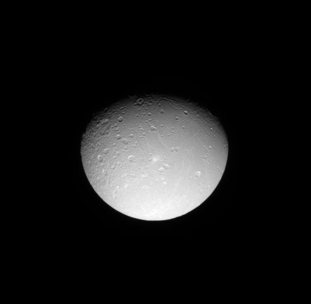
Dione’s Cratered Surface
- Click the image above for a larger view
- Full-Res JPEG (616 x 602) (12.7 kB)
- Full-Res TIFF (616 x 602) (371.4 kB)
Caption:
The Cassini spacecraft looks down on the cratered northern leading hemisphere of Dione, showing the moon's pockmarked surface.
This view is centered on terrain at 42 degrees north latitude, 131 degrees west longitude. Lit terrain seen here is on the leading hemisphere and anti-Saturn side of Dione (1,123 kilometers, or 698 miles across). The north pole of Dione lies along the terminator to the left of the top of the image.
The image was taken in visible light with the Cassini spacecraft narrow-angle camera on June 11, 2009. The view was acquired at a distance of approximately 641,000 kilometers (399,000 miles) from Dione and at a Sun-Dione-spacecraft, or phase, angle of 44 degrees. Image scale is 4 kilometers (2 miles) per pixel.
Background Info:
The Cassini-Huygens mission is a cooperative project of NASA, the European Space Agency and the Italian Space Agency. The Jet Propulsion Laboratory, a division of the California Institute of Technology in Pasadena, manages the mission for NASA's Science Mission Directorate, Washington, D.C. The Cassini orbiter and its two onboard cameras were designed, developed and assembled at JPL. The imaging operations center is based at the Space Science Institute in Boulder, Colo.
For more information about the Cassini-Huygens mission visit http://saturn.jpl.nasa.gov/ . The Cassini imaging team homepage is at http://ciclops.org .
Cataloging Keywords:
| Name | Value | Additional Values |
|---|---|---|
| Target | Dione | Saturn |
| System | Saturn | |
| Target Type | Satellite | Planet |
| Mission | Cassini-Huygens | |
| Instrument Host | Cassini Orbiter | |
| Host Type | Orbiter | |
| Instrument | Imaging Science Subsystem (ISS) | |
| Detector | Narrow Angle Camera | |
| Extra Keywords | Crater, Grayscale, Visual | |
| Acquisition Date | ||
| Release Date | 2009-10-12 | |
| Date in Caption | 2009-06-11 | |
| Image Credit | NASA/JPL/Space Science Institute | |
| Source | photojournal.jpl.nasa.gov/catalog/PIA11599 | |
| Identifier | PIA11599 | |