skip to navigation

|
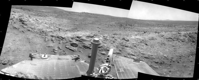
Spirit Beside ‘Home Plate,’ Sol 1809
- Click the image above for a larger view
- Full-Res JPEG (2601 x 1048) (367.0 kB)
- Full-Res TIFF (2601 x 1048) (2.7 MB)
Caption:
NASA Mars Exploration Rover Spirit used its navigation camera to take the images assembled into this 120-degree view southward after a short drive during the 1,809th Martian day, or sol, of Spirit's mission on the surface of Mars (February 3, 2009).
Spirit had driven about 2.6 meters (8.5 feet) that sol, continuing a clockwise route around a low plateau called "Home Plate." In this image, the rocks visible above the rovers' solar panels are on the slope at the northern edge of Home Plate.
This view is presented as a cylindrical projection with geometric seam correction.
Cataloging Keywords:
| Name | Value | Additional Values |
|---|---|---|
| Target | Mars | |
| System | ||
| Target Type | Planet | |
| Mission | Mars Exploration Rover (MER) | |
| Instrument Host | Spirit (MER-A) | |
| Host Type | Rover | |
| Instrument | Navigation Camera (Navcam) | |
| Detector | ||
| Extra Keywords | Grayscale | |
| Acquisition Date | ||
| Release Date | 2009-02-17 | |
| Date in Caption | 2009-02-03 | |
| Image Credit | NASA/JPL-Caltech | |
| Source | photojournal.jpl.nasa.gov/catalog/PIA11804 | |
| Identifier | PIA11804 | |
