
|
Using Reprojections to Examine Mercury’s Surface
- Click the image above for a larger view
- Full-Res JPEG (574 x 574) (57.4 kB)
- Full-Res TIFF (574 x 574) (330.0 kB)
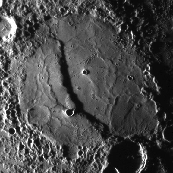
Caption:
The scarp cutting through this crater was imaged as MESSENGER approached the planet during the mission's second Mercury flyby. The full NAC image acquired by MDIS is shown in a previous release ( PIA11772 ) while the image shown here is a reprojected view. Compare the two images to see the differences.
By using very precise knowledge about the time that the image was taken and the location of the spacecraft at that time, the original image can be mapped onto a globe of Mercury. Once mapped onto a Mercury globe, that globe can be viewed in many different ways, including reprojections that create flat maps of Mercury's surface, as seen in this global map of Mercury ( PIA11403 ). The reprojected image shown here is from a simple cylindrical map projection. Map projections are needed to measure accurately the extent of features on the surface. For example, from this reprojection it was determined that this scarp is about 1 kilometer (0.6 miles) high and over 160 kilometers (100 miles) in length. MESSENGER Science Team members recently published an image similar to this reprojection in Science magazine.
Date Acquired:
October 6, 2008
Image Mission Elapsed Time (MET):
131766501
Instrument:
Narrow Angle Camera (NAC) of the Mercury Dual Imaging System (MDIS)
Resolution:
420 meters/pixel (0.26 miles)
Scale:
This crater is about 200 kilometers (124 miles) in diameter
Spacecraft Altitude:
16,300 kilometers (10,100 miles)
Background Info:
These images are from MESSENGER, a NASA Discovery mission to conduct the first orbital study of the innermost planet, Mercury. For information regarding the use of images, see the MESSENGER image use policy .
Cataloging Keywords:
| Name | Value | Additional Values |
|---|---|---|
| Target | Mercury | |
| System | ||
| Target Type | Planet | |
| Mission | MESSENGER | |
| Instrument Host | MESSENGER | |
| Host Type | Orbiter | |
| Instrument | Mercury Dual Imaging System (MDIS) | |
| Detector | Narrow Angle Camera (NAC) | |
| Extra Keywords | Crater, Grayscale, Map | |
| Acquisition Date | ||
| Release Date | 2009-06-02 | |
| Date in Caption | 2008-10-06 | |
| Image Credit | NASA/Johns Hopkins University Applied Physics Laboratory/Arizona State University/Carnegie Institution of Washington | |
| Source | photojournal.jpl.nasa.gov/catalog/PIA12054 | |
| Identifier | PIA12054 | |