|
Spirit’s Look Ahead After Sol 1866 Drive
- Click the image above for a larger view
- Full-Res JPEG (2638 x 1062) (313.9 kB)
- Full-Res TIFF (2638 x 1062) (2.8 MB)
Caption:
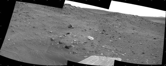
This scene combines three frames taken by the navigation camera on NASA's Mars Exploration Rover Spirit during the 1,866th Martian day, or sol, of Spirit's mission on Mars (April 3, 2009). It spans 120 degrees, with south at the center.
Spirit had driven 3 meters (10 feet) southward earlier in the day. The foreground of this view includes terrain that the rover covered in its next drive, when it progressed 17.5 meters (57 feet) farther southward on Sol 1868 (April 5, 2009).
In the middle distance, the western edge of the low plateau called "Home Plate" is on the left and a ridge called "Tsiolkovsky" is on the right, with the rover's planned route between the two. By Sol 1899 (May 6, 2009) Spirit became embedded at a site dubbed "Troy," about as far south as the northern end of Tsiolkovsky.
This view is presented as a cylindrical projection with geometric seam correction.
Cataloging Keywords:
| Name | Value | Additional Values |
|---|---|---|
| Target | Mars | |
| System | ||
| Target Type | Planet | |
| Mission | Mars Exploration Rover (MER) | |
| Instrument Host | Spirit (MER-A) | |
| Host Type | Rover | |
| Instrument | Navigation Camera (Navcam) | |
| Detector | ||
| Extra Keywords | Grayscale | |
| Acquisition Date | ||
| Release Date | 2009-07-16 | |
| Date in Caption | 2009-04-03 | 2009-04-05, 2009-05-06 |
| Image Credit | NASA/JPL-Caltech | |
| Source | photojournal.jpl.nasa.gov/catalog/PIA12136 | |
| Identifier | PIA12136 | |
