|
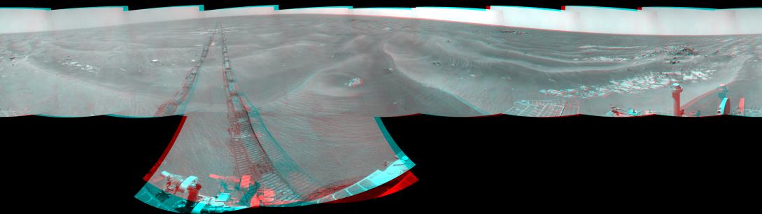
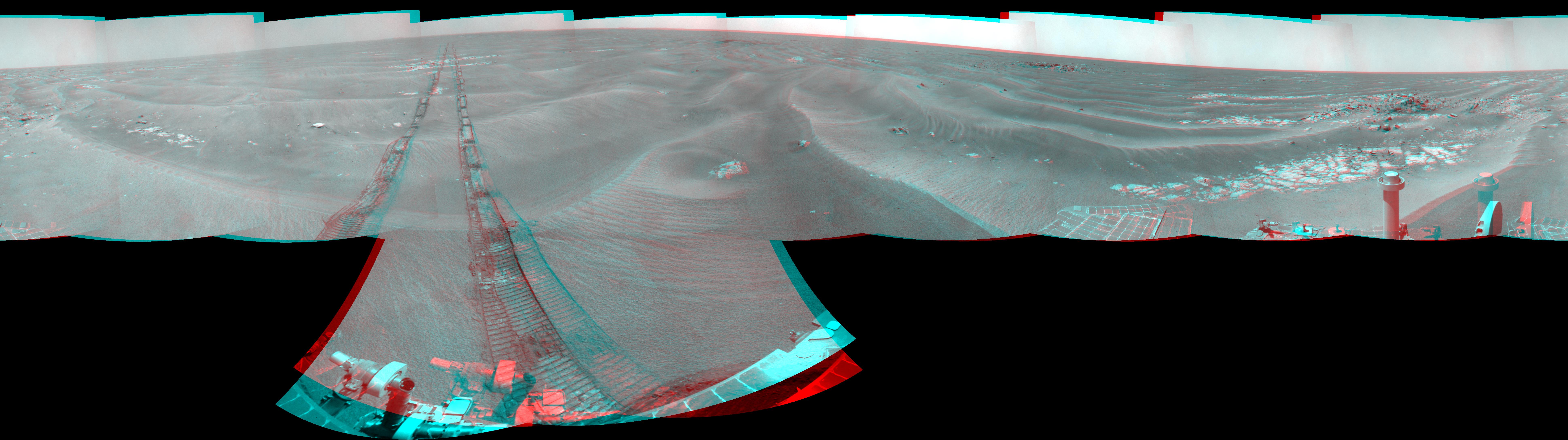
Opportunity’s Surroundings on Sol 1950 (Stereo)
- Click the image above for a larger view
- Full-Res JPEG (7753 x 2178) (1.4 MB)
- Full-Res TIFF (7753 x 2178) (50.7 MB)
Caption:
Left-eye view of a color stereo pair for PIA12143
Right-eye view of a color stereo pair for PIA12143
NASA's Mars Exploration Rover Opportunity used its navigation camera to take the images combined into this 360-degree stereo view of the rover's surroundings on the 1,950th Martian day, or sol, of its surface mission (July 19, 2009). The view appears three-dimensional when viewed through red-blue glasses with the red lens on the left. South is in the middle; north at both ends.
Opportunity had driven 60.8 meters (199 feet) that sol, moving backward as a strategy to mitigate an increased amount of current drawn by the drive motor in the right-front wheel. The rover was traveling a westward course, skirting a large field of impassable dunes to the south.
Much of the terrain surrounding the Sol 1950 position is wind-formed ripples of dark soil, with pale outcrop exposed in troughs between some ripples. A small crater visible nearby to the northwest is informally called "Kaiko." For scale, the distance between the parallel wheel tracks is about 1 meter (about 40 inches).
The site is about 3.8 kilometers (2.4 miles) south-southwest of Victoria Crater.
This panorama combines right-eye and left-eye views presented as cylindrical-perspective projections with geometric seam correction.
Cataloging Keywords:
| Name | Value | Additional Values |
|---|---|---|
| Target | Mars | |
| System | ||
| Target Type | Planet | |
| Mission | Mars Exploration Rover (MER) | |
| Instrument Host | Opportunity (MER-B) | |
| Host Type | Rover | |
| Instrument | Navigation Camera (Navcam) | |
| Detector | ||
| Extra Keywords | Color, Crater, Dune | |
| Acquisition Date | ||
| Release Date | 2009-07-23 | |
| Date in Caption | 2009-07-19 | |
| Image Credit | NASA/JPL-Caltech | |
| Source | photojournal.jpl.nasa.gov/catalog/PIA12154 | |
| Identifier | PIA12154 | |