|
Expected Depths to Ice, Mid-Latitude Northern Mars
- Click the image above for a larger view
- Full-Res JPEG (1375 x 810) (198.8 kB)
- Full-Res TIFF (1375 x 810) (3.3 MB)
Caption:
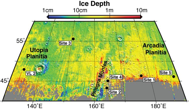
This map shows five locations where fresh impact cratering has excavated water ice from just beneath the surface of Mars (sites 1 through 5) and the Viking Lander 2 landing site (VL2), in the context of color coding to indicate estimated depth to ice.
The map covers an area from 40 to 60 degrees north latitude and from 130 to 190 degrees east longitude. Estimates of the depth to water-ice come from a computer model and observations of the brightness and temperature of the surface. The model matches the ice-exposing crater observations by NASA's Mars Reconnaissance Orbiter and data from the neutron spectrometer on NASA's Mars Odyssey orbiter.
Analysis of the observations of ice-exposing fresh craters at sites 1 through 5, reported by Byrne et al . in a Sept. 25, 2009, paper in the journal Science, leads the paper's authors to calculate that if NASA's Viking Lander 2 had been able to dig slightly deeper than the 10-to 15-centimeter-deep (4-to-6-inch-deep) trench that it excavated in 1976, it would have hit water ice.
The color coding indicates depths to the top of a water-ice-containing layer, ranging from 1 centimeter (about half an inch) in dark-blue coded locations to 10 meters (33 feet) in red-coded locations.
Cataloging Keywords:
| Name | Value | Additional Values |
|---|---|---|
| Target | Mars | |
| System | ||
| Target Type | Planet | |
| Mission | Mars Reconnaissance Orbiter (MRO) | 2001 Mars Odyssey, Viking |
| Instrument Host | Mars Reconnaissance Orbiter | Mars Odyssey |
| Host Type | Orbiter | |
| Instrument | ||
| Detector | ||
| Extra Keywords | Color, Crater, Impact, Map, Water | |
| Acquisition Date | ||
| Release Date | 2009-09-24 | |
| Date in Caption | ||
| Image Credit | NASA/JPL/University of Arizona | |
| Source | photojournal.jpl.nasa.gov/catalog/PIA12214 | |
| Identifier | PIA12214 | |