|
Crater Formed in 2008 Reveals Subsurface Ice
- Click the image above for a larger view
- Full-Res JPEG (570 x 280) (20.3 kB)
- Full-Res TIFF (570 x 280) (479.6 kB)
Caption:
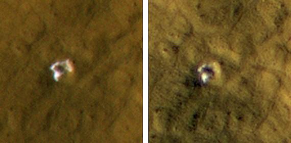
This 6-meter-wide (20-foot-wide) crater in mid-latitude northern Mars was created by an impact that occurred between Jan. 22, 2008, and Sept. 15, 2008, as bracketed by before-and-after images not shown here. The images shown here were taken by the High Resolution Imaging Science Experiment camera on NASA's Mars Reconnaissance Orbiter on Oct. 29, 2008, (left) and on Jan. 4, 2009. Each image is 35 meters (115 feet) across. The crater's depth is estimated at 1.76 meters (5.8 feet).
The impact that dug the crater excavated water ice from beneath the surface. It is the bright material visible in this pair of images. A change in appearance from the earlier image to the later one resulted from some of the ice sublimating away during the northern-hemisphere summer, leaving behind dust that had been intermixed with the ice. The thickening layer of dust on top obscured some of the remaining ice. This crater is at 45.05 degrees north latitude, 164.71 degrees east longitude.
These images are subframes of full-frame images that are available online at at http://hirise.lpl.arizona.edu/PSP_010585_2255 and http://hirise.lpl.arizona.edu/ESP_011442_2255 .
Cataloging Keywords:
| Name | Value | Additional Values |
|---|---|---|
| Target | Mars | |
| System | ||
| Target Type | Planet | |
| Mission | Mars Reconnaissance Orbiter (MRO) | |
| Instrument Host | Mars Reconnaissance Orbiter | |
| Host Type | Orbiter | |
| Instrument | High Resolution Imaging Science Experiment (HiRISE) | |
| Detector | ||
| Extra Keywords | Color, Crater, Dust, Impact, Water | |
| Acquisition Date | ||
| Release Date | 2009-09-24 | |
| Date in Caption | 2008-01-22 | 2008-10-29, 2009-01-04 |
| Image Credit | NASA/JPL-Caltech/University of Arizona | |
| Source | photojournal.jpl.nasa.gov/catalog/PIA12218 | |
| Identifier | PIA12218 | |