Perspective View of Layered Mound in Gale Crater, Mars
Caption:

Click on the image for larger version
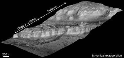
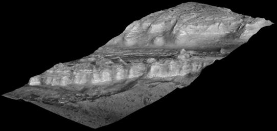
This oblique view shows geological layers of rock exposed on a mound inside Gale Crater on Mars. This is a lower portion of the mound, with the crater floor at the left (and lowest) edge of the image. Layers near the bottom of the mound contain clay and sulfate minerals that indicate wet conditions. Overlying rock layers contain sulfates with little or no clay, consistent with these layers forming in an environment in which water was evaporating and Mars was drying out.
This view was created from a three-dimensional topographic model of the mound. The U.S. Geological Survey generated the model from a stereo pair of images taken by the High Resolution Imaging Science Experiment (HiRISE) camera on NASA's Mars Reconnaissance Orbiter. Observations of the site by the Compact Reconnaissance Imaging Spectrometer for Mars, on the same orbiter, yielded information about composition. The vertical dimension is exaggerated three-fold relative to the horizontal dimensions. The view is toward the southeast. The width of the area included in the image is about 1.5 kilometers (about 5,000 feet). The scale bar in the labeled version is 200 meters (656 feet).
Gale Crater is approximately 152 kilometers (94 miles) in diameter and centered at about 5 degrees south latitude, 138 degrees east longitude. The mound near its center is over 4 kilometers (2.4 miles) high, making it more than twice as thick as the stack of rocks exposed in the Grand Canyon on Earth.
This image combines data from HiRISE observations PSP_001488_1750, taken on Nov. 20, 2006, and PSP_001752_1750, taken Dec. 10, 2006. Other image products from these observation are available at
http://hirise.lpl.arizona.edu/PSP_001488_1750
and
http://hirise.lpl.arizona.edu/PSP_001752_1750
.
Background Info:
The University of Arizona, Tucson, operates the HiRISE camera, which was built by Ball Aerospace & Technologies Corp., Boulder, Colo. NASA's Jet Propulsion Laboratory, a division of the California Institute of Technology, Pasadena, manages the Mars Reconnaissance Orbiter for the NASA Science Mission Directorate, Washington. Lockheed Martin Space Systems, Denver, is the prime contractor for the project and built the spacecraft.
Cataloging Keywords:
| Name |
Value |
Additional Values |
| Target |
Mars |
|
| System |
|
|
| Target Type |
Planet |
|
| Mission |
Mars Reconnaissance Orbiter (MRO) |
|
| Instrument Host |
Mars Reconnaissance Orbiter |
|
| Host Type |
Orbiter |
|
| Instrument |
Compact Reconnaissance Imaging Spectrometer for Mars (CRISM) |
High Resolution Imaging Science Experiment (HiRISE) |
| Detector |
|
|
| Extra Keywords |
Crater, Grayscale, Water |
| Acquisition Date |
|
| Release Date |
2010-02-11 |
| Date in Caption |
2006-11-20 |
2006-12-10 |
| Image Credit |
NASA/JPL-Caltech/University of Arizona/USGS |
| Source |
photojournal.jpl.nasa.gov/catalog/PIA12507 |
| Identifier |
PIA12507 |

 Planetary Data System

