
|
Charting Atlas’ Path
- Click the image above for a larger view
- Full-Res JPEG (1016 x 315) (14.9 kB)
- Full-Res TIFF (1016 x 315) (320.6 kB)
Caption:
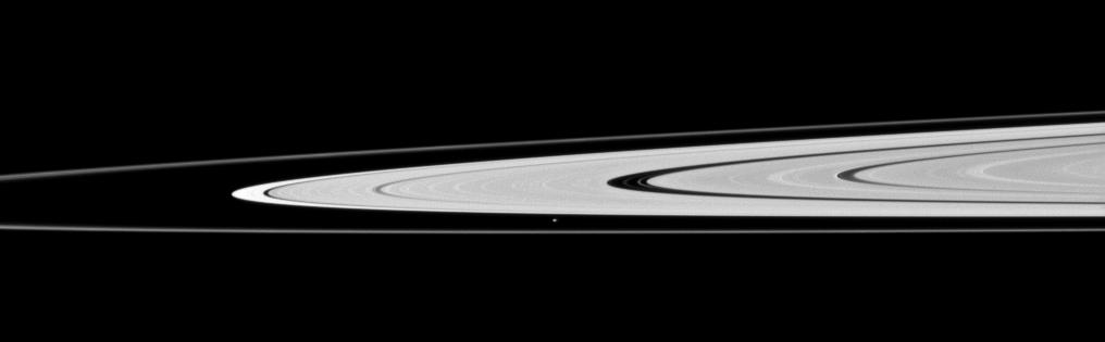
Saturn's moon Atlas, just below the center of this image, orbits in the Roche Division between the A ring and thin F ring.
See PIA08405 for higher resolution views of Atlas (30 kilometers, or 19 miles across). This view looks toward the northern, sunlit side of the rings from just above the ringplane.
The image was taken in visible light with the Cassini spacecraft narrow-angle camera on Nov. 23, 2009. The view was acquired at a distance of approximately 1.4 million kilometers (870,000 miles) from Atlas. Image scale is 9 kilometers (6 miles) per pixel.
Background Info:
The Cassini-Huygens mission is a cooperative project of NASA, the European Space Agency and the Italian Space Agency. The Jet Propulsion Laboratory, a division of the California Institute of Technology in Pasadena, manages the mission for NASA's Science Mission Directorate, Washington, D.C. The Cassini orbiter and its two onboard cameras were designed, developed and assembled at JPL. The imaging operations center is based at the Space Science Institute in Boulder, Colo.
For more information about the Cassini-Huygens mission visit http://saturn.jpl.nasa.gov . The Cassini imaging team homepage is at http://ciclops.org .
Cataloging Keywords:
| Name | Value | Additional Values |
|---|---|---|
| Target | Atlas | A Ring, Saturn Rings |
| System | Saturn | |
| Target Type | Satellite | Ring |
| Mission | Cassini-Huygens | |
| Instrument Host | Cassini Orbiter | |
| Host Type | Orbiter | |
| Instrument | Imaging Science Subsystem (ISS) | |
| Detector | Narrow Angle Camera | |
| Extra Keywords | Grayscale, Visual | |
| Acquisition Date | ||
| Release Date | 2010-03-23 | |
| Date in Caption | 2009-11-23 | |
| Image Credit | NASA/JPL/Space Science Institute | |
| Source | photojournal.jpl.nasa.gov/catalog/PIA12595 | |
| Identifier | PIA12595 | |