|
Location Map for Images of Changing Martian Dunes
- Click the image above for a larger view
- Full-Res JPEG (535 x 645) (82.6 kB)
- Full-Res TIFF (535 x 645) (345.6 kB)
Caption:
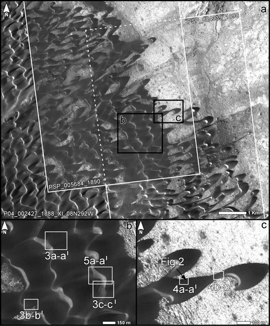
The upper portion of this map is from an observation by the Context Camera on NASA's Mars Reconnaissance Orbiter of a field of dark sand dunes in the Nili Patera region of Mars. The white inscribed rectangles show overlapping footprints of observations made by the same orbiter's High Resolution Imaging Science Experiment camera 15 months apart. The black inscribed boxes show locations of two portions of the image seen in magnified view below, "b" on the left and "c" on the right.
The map serves to show the context and location of images comparing before and after views to identify changes in the ripples on the dunes ( PIA12860 ), the edges of the dunes ( PIA12859 ) and the slip face of a dune ( PIA12858 ).
The site is at 9 degrees north latitude, 67 degrees east longitude. The white scale bar in the top image is 1 kilometer (0.62 mile) long. The scale bars in the two bottom images are 150 meters (492 feet) long. North is toward the top in all three images.
Background Info:
Malin Space Science Systems, San Diego, provided and operates the Context Camera. NASA's Jet Propulsion Laboratory, a division of the California Institute of Technology, Pasadena, manages the Mars Reconnaissance Orbiter for the NASA Science Mission Directorate, Washington. Lockheed Martin Space Systems, Denver, is the spacecraft development and integration contractor for the project and built the spacecraft.
Cataloging Keywords:
| Name | Value | Additional Values |
|---|---|---|
| Target | Mars | |
| System | ||
| Target Type | Planet | |
| Mission | Mars Reconnaissance Orbiter (MRO) | |
| Instrument Host | Mars Reconnaissance Orbiter | |
| Host Type | Orbiter | |
| Instrument | Context Camera (CTX) | |
| Detector | ||
| Extra Keywords | Dune, Grayscale, Map | |
| Acquisition Date | ||
| Release Date | 2010-03-04 | |
| Date in Caption | ||
| Image Credit | NASA/JPL-Caltech/MSSS | |
| Source | photojournal.jpl.nasa.gov/catalog/PIA12857 | |
| Identifier | PIA12857 | |