|
Mars Odyssey All Stars: Ares Vallis
- Click the image above for a larger view
- Full-Res JPEG (2652 x 2824) (2.1 MB)
- Full-Res TIFF (2652 x 2824) (22.5 MB)
Caption:
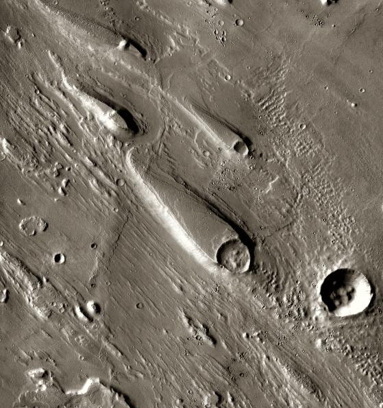
In Ares Vallis, teardrop mesas extend like pennants behind impact craters, where the raised rocky rims diverted the floods and protected the ground from erosion. Scientists estimate the floods had peak volumes many times the flow of today's Mississippi River.
This image was taken by the Thermal Emission Imaging System instrument on NASA's Mars Odyssey orbiter and posted in a special December 2010 set marking the occasion of Odyssey becoming the longest-working Mars spacecraft in history. The pictured location on Mars is 15.9 degrees north latitude, 330 degrees east longitude.
Background Info:
NASA's Jet Propulsion Laboratory manages the 2001 Mars Odyssey mission for NASA's Science Mission Directorate, Washington, D.C. The Thermal Emission Imaging System (THEMIS) was developed by Arizona State University, Tempe, in collaboration with Raytheon Santa Barbara Remote Sensing. The THEMIS investigation is led by Dr. Philip Christensen at Arizona State University. Lockheed Martin Astronautics, Denver, is the prime contractor for the Odyssey project, and developed and built the orbiter. Mission operations are conducted jointly from Lockheed Martin and from JPL, a division of the California Institute of Technology in Pasadena.
Cataloging Keywords:
| Name | Value | Additional Values |
|---|---|---|
| Target | Mars | |
| System | ||
| Target Type | Planet | |
| Mission | 2001 Mars Odyssey | |
| Instrument Host | Mars Odyssey | |
| Host Type | Orbiter | |
| Instrument | Thermal Emission Imaging System (THEMIS) | |
| Detector | ||
| Extra Keywords | Color, Crater, Impact, Thermal | |
| Acquisition Date | ||
| Release Date | 2010-12-09 | |
| Date in Caption | ||
| Image Credit | NASA/JPL-Caltech/ASU | |
| Source | photojournal.jpl.nasa.gov/catalog/PIA13653 | |
| Identifier | PIA13653 | |