|
Mars Odyssey All Stars: Noctis Canyon
- Click the image above for a larger view
- Full-Res JPEG (1635 x 2300) (731.0 kB)
- Full-Res TIFF (1635 x 2300) (11.3 MB)
Caption:
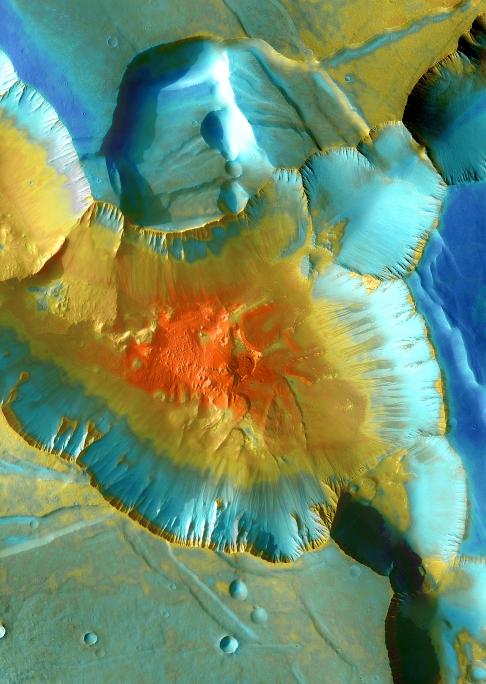
A false-color mosaic focuses on one junction in Noctis Labyrinthus where canyons meet to form a depression 4,000 meters (13,000 feet) deep. Dust (blue tints) lies on the upper surfaces, while rockier material (warmer colors) lies below.
The pictures used to create this mosaic image were taken from April 2003 to September 2005 by the Thermal Emission Imaging System instrument on NASA's Mars Odyssey orbiter. It is part of a special set of images marking the occasion of Odyssey becoming the longest-working Mars spacecraft in history. The pictured location on Mars is approximately 13 degrees south latitude, 260 degrees east longitude.
Background Info:
NASA's Jet Propulsion Laboratory manages the 2001 Mars Odyssey mission for NASA's Science Mission Directorate, Washington, D.C. The Thermal Emission Imaging System (THEMIS) was developed by Arizona State University, Tempe, in collaboration with Raytheon Santa Barbara Remote Sensing. The THEMIS investigation is led by Dr. Philip Christensen at Arizona State University. Lockheed Martin Astronautics, Denver, is the prime contractor for the Odyssey project, and developed and built the orbiter. Mission operations are conducted jointly from Lockheed Martin and from JPL, a division of the California Institute of Technology in Pasadena.
Cataloging Keywords:
| Name | Value | Additional Values |
|---|---|---|
| Target | Mars | |
| System | ||
| Target Type | Planet | |
| Mission | 2001 Mars Odyssey | |
| Instrument Host | Mars Odyssey | |
| Host Type | Orbiter | |
| Instrument | Thermal Emission Imaging System (THEMIS) | |
| Detector | ||
| Extra Keywords | Color, Dust, Thermal | |
| Acquisition Date | ||
| Release Date | 2010-12-09 | |
| Date in Caption | ||
| Image Credit | NASA/JPL-Caltech/ASU | |
| Source | photojournal.jpl.nasa.gov/catalog/PIA13656 | |
| Identifier | PIA13656 | |