|
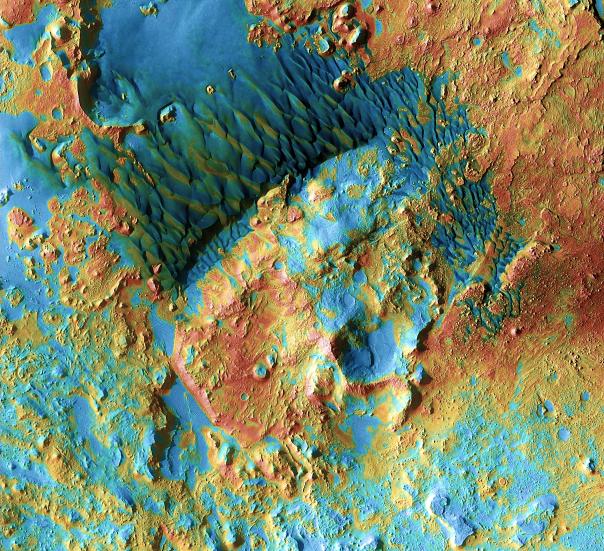
Mars Odyssey All Stars: Arabia Dunes
- Click the image above for a larger view
- Full-Res JPEG (2092 x 1907) (1.4 MB)
- Full-Res TIFF (2092 x 1907) (12.0 MB)
Caption:
Sand dunes shaped like blue-black flames lie next to a central hill within an unnamed, 120-kilometer-wide (75-mile-wide) crater in eastern Arabia on Mars. False colors depict the nature of the ground surface: Areas in bluish tints have more fine sand at the surface, while redder tints indicate harder sediments and outcrops of rock.
This scene combines images taken during the period from February 2003 to August 2004 by the Thermal Emission Imaging System instrument on NASA's Mars Odyssey orbiter. It is part of a special set of images marking the occasion of Odyssey becoming the longest-working Mars spacecraft in history. The pictured location on Mars is 26.7 degrees north latitude, 63 degrees east longitude.
Background Info:
NASA's Jet Propulsion Laboratory manages the 2001 Mars Odyssey mission for NASA's Science Mission Directorate, Washington, D.C. The Thermal Emission Imaging System (THEMIS) was developed by Arizona State University, Tempe, in collaboration with Raytheon Santa Barbara Remote Sensing. The THEMIS investigation is led by Dr. Philip Christensen at Arizona State University. Lockheed Martin Astronautics, Denver, is the prime contractor for the Odyssey project, and developed and built the orbiter. Mission operations are conducted jointly from Lockheed Martin and from JPL, a division of the California Institute of Technology in Pasadena.
Cataloging Keywords:
| Name | Value | Additional Values |
|---|---|---|
| Target | Mars | |
| System | ||
| Target Type | Planet | |
| Mission | 2001 Mars Odyssey | |
| Instrument Host | Mars Odyssey | |
| Host Type | Orbiter | |
| Instrument | Thermal Emission Imaging System (THEMIS) | |
| Detector | ||
| Extra Keywords | Color, Crater, Dune, Thermal | |
| Acquisition Date | ||
| Release Date | 2010-12-09 | |
| Date in Caption | ||
| Image Credit | NASA/JPL-Caltech/ASU | |
| Source | photojournal.jpl.nasa.gov/catalog/PIA13658 | |
| Identifier | PIA13658 | |