|
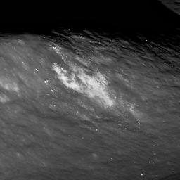
Aitken Central Peak, Seen Obliquely
- Click the image above for a larger view
- Full-Res JPEG (1600 x 1600) (260.7 kB)
- Full-Res TIFF (1600 x 1600) (2.6 MB)
Caption:
Southern end of Aitken crater central peak complex. The upper left is about 1000 meters (3280 feet) above the crater floor, which is just seen at lower right. Bright material (high albedo) may be a landslide of local soil, or a secondary impact from a small nearby impact crater. Distance along ridge line is ~4 kilometers (~2.5 miles).
Background Info:
NASA's Goddard Space Flight Center built and manages the mission for the Exploration Systems Mission Directorate at NASA Headquarters in Washington. The Lunar Reconnaissance Orbiter Camera was designed to acquire data for landing site certification and to conduct polar illumination studies and global mapping. Operated by Arizona State University, LROC consists of a pair of narrow-angle cameras (NAC) and a single wide-angle camera (WAC). The mission is expected to return over 70 terabytes of image data.
Cataloging Keywords:
| Name | Value | Additional Values |
|---|---|---|
| Target | Moon | |
| System | Earth | |
| Target Type | Satellite | |
| Mission | Lunar Reconnaissance Orbiter (LRO) | |
| Instrument Host | Lunar Reconnaissance Orbiter | |
| Host Type | Orbiter | |
| Instrument | Lunar Reconnaissance Orbiter Camera (NAC) | |
| Detector | Narrow Angle Camera (NAC), Wide Angle Camera (WAC) | |
| Extra Keywords | Crater, Grayscale, Impact | |
| Acquisition Date | ||
| Release Date | 2011-01-17 | |
| Date in Caption | ||
| Image Credit | NASA/GSFC/Arizona State University | |
| Source | photojournal.jpl.nasa.gov/catalog/PIA13819 | |
| Identifier | PIA13819 | |
