|
Don’t Get Weird On Me, Babe
- Click the image above for a larger view
- Full-Res JPEG (1024 x 1020) (167.5 kB)
- Full-Res TIFF (1024 x 1020) (1.0 MB)
Caption:
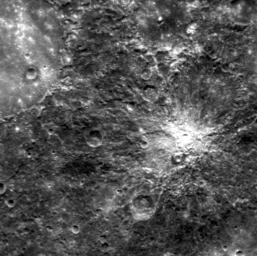
The large, smooth area in the upper left is the floor of the crater Petrarch. The more rugged terrain around Petrarch has an unusual "hilly and lineated" texture that Mariner 10 team members called "weird terrain" upon seeing it for the first time. This area may have been modified by converging seismic waves and/or ejecta from the formation of the Caloris basin, which is located on the opposite side of the planet. In April 2011, MESSENGER viewed this area under differing lighting conditions than those seen during MESSENGER's second flyby and Mariner 10's first pass.
This image was acquired as part of MDIS's high-resolution surface morphology base map. The surface morphology base map will cover more than 90% of Mercury's surface with an average resolution of 250 meters/pixel (0.16 miles/pixel or 820 feet/pixel). Images acquired for the surface morphology base map typically have off-vertical Sun angles (i.e., high incidence angles) and visible shadows so as to reveal clearly the topographic form of geologic features.
Date acquired:
April 05, 2011
Image Mission Elapsed Time (MET):
210451707
Image ID:
91712
Instrument:
Narrow Angle Camera (NAC) of the Mercury Dual Imaging System (MDIS)
Center Latitude:
-33.5°
Center Longitude:
337.2° E
Resolution:
284 meters/pixel
Scale:
The scene is about 285 km (177 mi.) across
Background Info:
On March 17, 2011 (March 18, 2011, UTC), MESSENGER became the first spacecraft ever to orbit the planet Mercury . The mission is currently in its commissioning phase, during which spacecraft and instrument performance are verified through a series of specially designed checkout activities. In the course of the one-year primary mission, the spacecraft's seven scientific instruments and radio science investigation will unravel the history and evolution of the Solar System's innermost planet. Visit the Why Mercury? section of this website to learn more about the science questions that the MESSENGER mission has set out to answer.
These images are from MESSENGER, a NASA Discovery mission to conduct the first orbital study of the innermost planet, Mercury. For information regarding the use of images, see the MESSENGER image use policy .
Cataloging Keywords:
| Name | Value | Additional Values |
|---|---|---|
| Target | Mercury | |
| System | ||
| Target Type | Planet | |
| Mission | MESSENGER | Mariner |
| Instrument Host | MESSENGER | Mariner 10 |
| Host Type | Orbiter | Flyby Spacecraft |
| Instrument | Mercury Dual Imaging System (MDIS) | |
| Detector | Narrow Angle Camera (NAC) | |
| Extra Keywords | Crater, Grayscale, Map, Radio, Shadow | |
| Acquisition Date | ||
| Release Date | 2011-04-18 | |
| Date in Caption | 2011-04-05 | |
| Image Credit | NASA/Johns Hopkins University Applied Physics Laboratory/Carnegie Institution of Washington | |
| Source | photojournal.jpl.nasa.gov/catalog/PIA14200 | |
| Identifier | PIA14200 | |
