|
Monitoring Mercury’s South Pole
- Click the image above for a larger view
- Full-Res JPEG (2768 x 2135) (631.5 kB)
- Full-Res TIFF (2768 x 2135) (5.9 MB)
Caption:
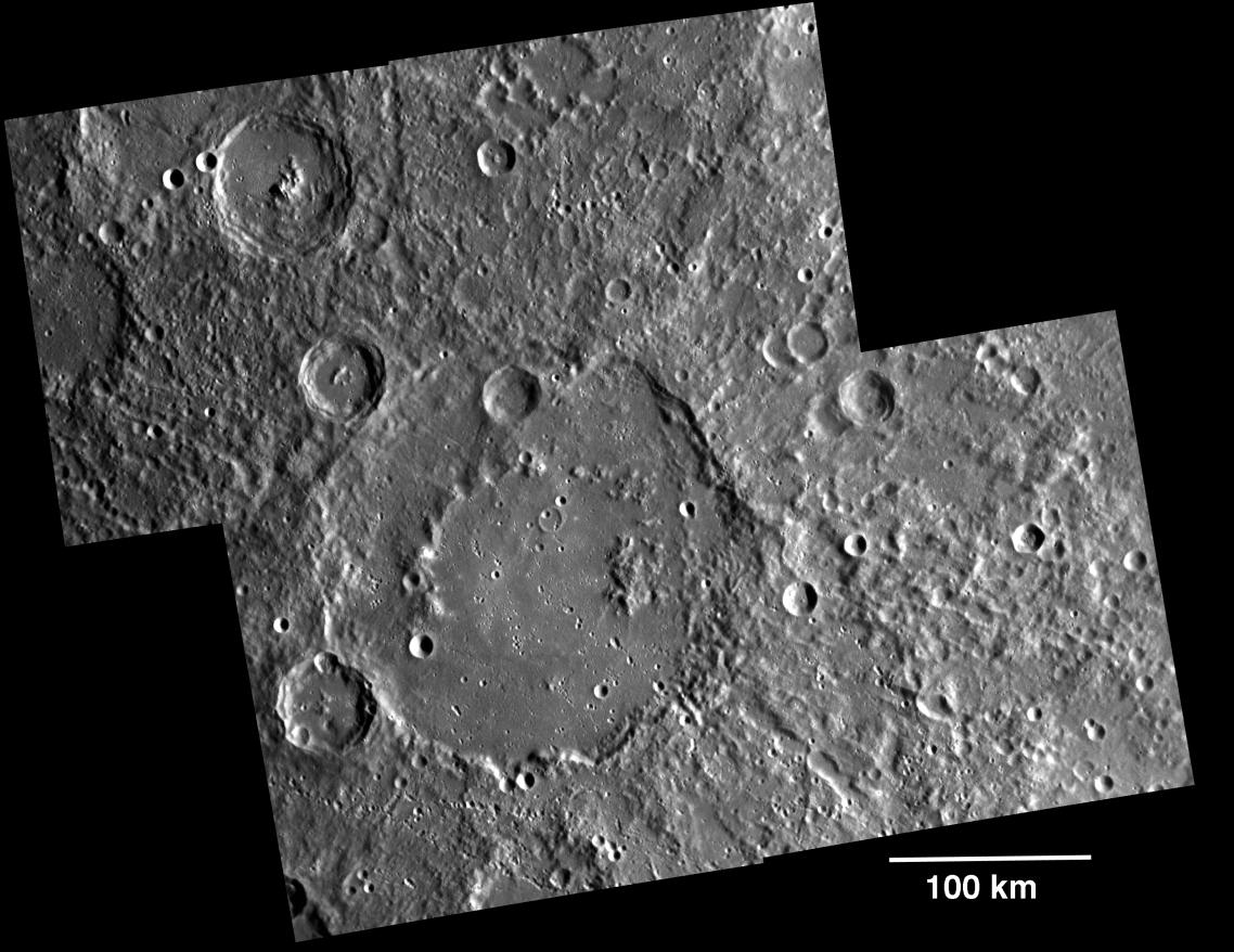
During the first 176 days of the orbital mission, equal to one solar day on Mercury, MDIS will acquire images to produce a high-resolution base map for surface morphology (morphology is the term given to the shape and texture of the surface). This map will cover more than 90% of Mercury's surface at an average resolution of 250 m/pixel (0.16 miles/pixel or 820 feet/pixel) or better. At this resolution, features about 1 km in horizontal scale are recognizable in the images. Images acquired for the surface morphology base map have off-vertical solar illumination and visible shadows so as to reveal clearly the topographic form of geologic features. Because of MESSENGER's highly elliptical orbit , the spacecraft passes close to the surface at high northern latitudes but is far above the southern hemisphere, so both the NAC and the WAC are being used to construct the global base map. For the southern hemisphere, images are obtained with the NAC, which has a 1.5° field of view and can acquire images at seven times greater resolution than the WAC. For the northern hemisphere, when the spacecraft is closer to and moving faster over the surface, the WAC is used, because its 10.5° field of view enables good image coverage. Images from both the NAC and the WAC will be mosaicked together to produce the global map. Shown here is an example mosaic of four images acquired as part of the surface morphology campaign. The large crater in the center is Valmiki (210 km diameter). Read this featured story to learn more about MDIS's other imaging campaigns.
Date acquired:
April 24, 2011
Image Mission Elapsed Time (MET):
212149353, 212149359, 212150284, 212150288
Image ID:
171563-6
Instrument:
Narrow Angle Camera (NAC) of the Mercury Dual Imaging System (MDIS)
Center Latitude:
-22.63°
Center Longitude:
219.7° E
Resolution:
216 meters/pixel
Scale:
Scale bar of 100 kilometers shown on the image
Incidence Angle:
64.9°
Emission Angle:
6.9°
Phase Angle:
71.8°
Background Info:
On March 17, 2011 (March 18, 2011, UTC), MESSENGER became the first spacecraft ever to orbit the planet Mercury . The mission is currently in its commissioning phase, during which spacecraft and instrument performance are verified through a series of specially designed checkout activities. In the course of the one-year primary mission, the spacecraft's seven scientific instruments and radio science investigation will unravel the history and evolution of the Solar System's innermost planet. Visit the Why Mercury? section of this website to learn more about the science questions that the MESSENGER mission has set out to answer.
These images are from MESSENGER, a NASA Discovery mission to conduct the first orbital study of the innermost planet, Mercury. For information regarding the use of images, see the MESSENGER image use policy .
Cataloging Keywords:
| Name | Value | Additional Values |
|---|---|---|
| Target | Mercury | |
| System | ||
| Target Type | Planet | |
| Mission | MESSENGER | |
| Instrument Host | MESSENGER | |
| Host Type | Orbiter | |
| Instrument | Mercury Dual Imaging System (MDIS) | |
| Detector | Narrow Angle Camera (NAC) | |
| Extra Keywords | Crater, Grayscale, Map, Radio, Shadow | |
| Acquisition Date | ||
| Release Date | 2011-05-10 | |
| Date in Caption | 2011-04-24 | |
| Image Credit | NASA/Johns Hopkins University Applied Physics Laboratory/Carnegie Institution of Washington | |
| Source | photojournal.jpl.nasa.gov/catalog/PIA14234 | |
| Identifier | PIA14234 | |