
|
Mapping Beethoven
- Click the image above for a larger view
- Full-Res JPEG (1018 x 1799) (405.6 kB)
- Full-Res TIFF (1018 x 1799) (5.5 MB)
Caption:
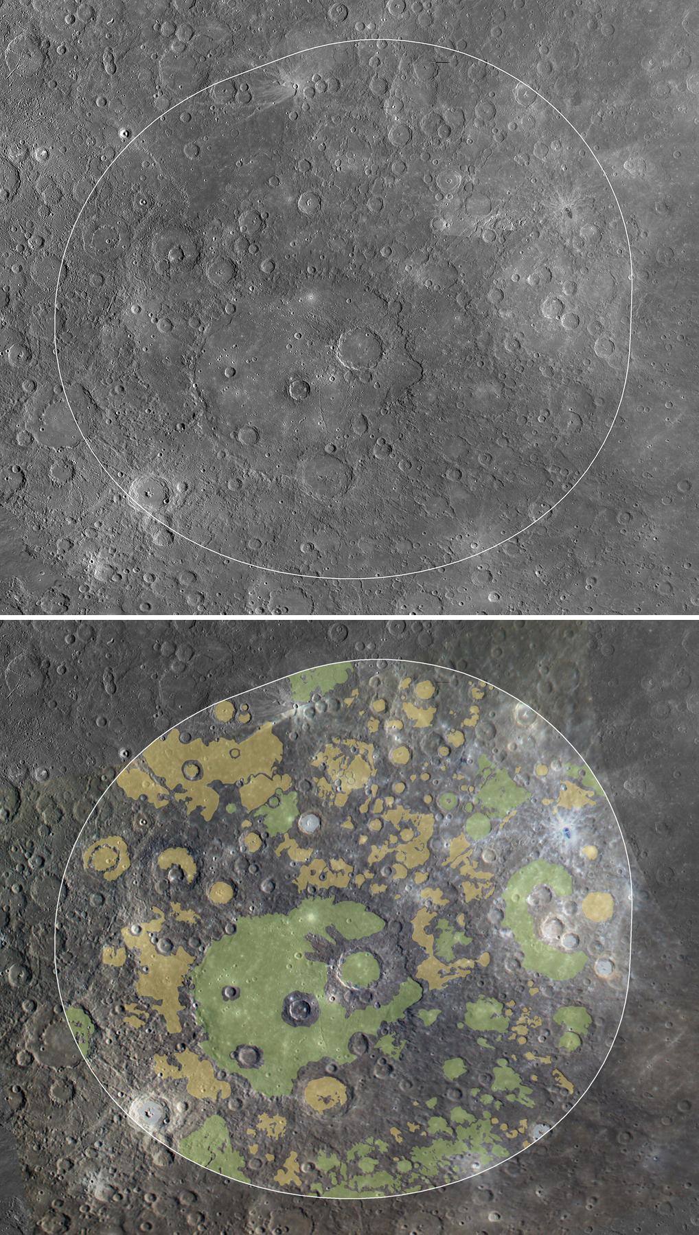
At top, the white line highlights the region of Mercury's surface visible to the XRS during a solar flare on 16 June 2011. Near the center is the ~650-km-diameter Beethoven impact basin at 21° S, 236° E. This region has a higher Mg/Si ratio than the northern plains and is closer in composition to terrestrial komatiites, low-silica, high-temperature volcanic rocks that formed only very early in Earth's history.
Below, smooth plains within the same area have been mapped. In green are plains of volcanic origin. These plains display flooding and embayment relationships and color contrasts typical of volcanic plains on Mercury. Yellow denotes plains of uncertain origin. Though they may also be volcanic, they lack definitive evidence for a volcanic origin and may have formed as fluidized impact ejecta, possibly from the Beethoven impact basin, or as impact melt. In blue are plains that formed when rock was melted by impacts. Even geologically complex regions, such as the area seen here, are often dominated by volcanic deposits, and their compositions are consistent with a volcanic origin.
Background Info:
These images are from MESSENGER, a NASA Discovery mission to conduct the first orbital study of the innermost planet, Mercury. For information regarding the use of images, see the MESSENGER image use policy .
Cataloging Keywords:
| Name | Value | Additional Values |
|---|---|---|
| Target | Mercury | |
| System | ||
| Target Type | Planet | |
| Mission | MESSENGER | |
| Instrument Host | MESSENGER | |
| Host Type | Orbiter | |
| Instrument | Mercury Dual Imaging System (MDIS) | |
| Detector | ||
| Extra Keywords | Color, Impact, Volcano | |
| Acquisition Date | ||
| Release Date | 2011-10-05 | |
| Date in Caption | 2011-06-16 | |
| Image Credit | NASA/Johns Hopkins University Applied Physics Laboratory/Carnegie Institution of Washington | |
| Source | photojournal.jpl.nasa.gov/catalog/PIA14864 | |
| Identifier | PIA14864 | |