|
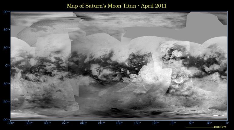
Map of Titan - April 2011
- Click the image above for a larger view
- Full-Res JPEG (4374 x 2430) (921.2 kB)
- Full-Res TIFF (4374 x 2430) (31.9 MB)
Caption:
This global digital map of Saturn's moon Titan was created using images taken by the Cassini spacecraft's imaging science subsystem (ISS).
The images were taken using a filter centered at 938 nanometers, allowing researchers to examine variations in albedo (or inherent brightness) variations across the surface of Titan. Because of the scattering of light by Titan's dense atmosphere, no topographic shading is visible in these images.
The map is an equidistant projection and has a scale of 2.5 miles (4 kilometers) per pixel. Actual resolution varies greatly across the map, with the best coverage (close to the map scale) along the equator near the center of the map at 180 degrees west longitude and near the left and right edges at 0 and 360 degrees west longitude. The worst coverage is on the leading hemisphere (particularly around 120 degrees west longitude) and in some northern latitudes. Coverage in the northern polar region continues to improve as the north pole comes out of shadow after Titan's northern vernal equinox in August 2009. Large dark areas, now known to be liquid-hydrocarbon-filled lakes, have been documented at high latitudes (see PIA11146 ).
This map is an update to the version released in February 2009 (see PIA11149 ). Data from the last two years, including the most recent data in the map from April 2011, have improved coverage in the southern trailing hemisphere and over portions of the north polar region.
The mean radius of Titan used for projection of this map is 1,600 miles (2,575 kilometers). Titan is assumed to be spherical until a control network -- or model of the moon's shape based on multiple images tied together at defined points on the surface -- is created at some point in the future.
Background Info:
The Cassini-Huygens mission is a cooperative project of NASA, the European Space Agency and the Italian Space Agency. The Jet Propulsion Laboratory, a division of the California Institute of Technology in Pasadena, manages the mission for NASA's Science Mission Directorate, Washington, D.C. The Cassini orbiter and its two onboard cameras were designed, developed and assembled at JPL. The imaging operations center is based at the Space Science Institute in Boulder, Colo.
For more information about the Cassini-Huygens mission visit http://saturn.jpl.nasa.gov . The Cassini imaging team homepage is at http://ciclops.org .
Cataloging Keywords:
| Name | Value | Additional Values |
|---|---|---|
| Target | Titan | |
| System | Saturn | |
| Target Type | Satellite | |
| Mission | Cassini-Huygens | |
| Instrument Host | Cassini Orbiter | |
| Host Type | Orbiter | |
| Instrument | Imaging Science Subsystem (ISS) | |
| Detector | ||
| Extra Keywords | Atmosphere, Color, Map, Shadow, Visual | |
| Acquisition Date | ||
| Release Date | 2011-10-26 | |
| Date in Caption | ||
| Image Credit | NASA/JPL-Caltech/Space Science Institute | |
| Source | photojournal.jpl.nasa.gov/catalog/PIA14908 | |
| Identifier | PIA14908 | |