|
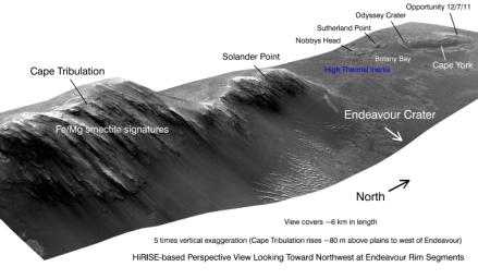
West Rim of Endeavour with Vertical Exaggeration
- Click the image above for a larger view
- Full-Res JPEG (8192 x 4774) (3.0 MB)
- Full-Res TIFF (8192 x 4774) (117.3 MB)
Caption:
This view shows portions of the western rim of Endeavour Crater on Mars from a perspective looking toward the northwest. The image exaggerates the landscape's vertical dimension five-fold compared with horizontal dimensions. The scene covers about 4 miles (6 kilometers) in length. Major portions of the rim are labeled.
The view was generated by producing an elevation map from a stereo pair of images from the High Resolution Imaging Science Experiment (HiRISE) camera on NASA's Mars Reconnaissance Orbiter, then draping one of the HiRISE images over the elevation model. Other image products from the HiRISE observations used in generating this view are at http://hirise.lpl.arizona.edu/ESP_018701_1775 and http://hirise.lpl.arizona.edu/ESP_018846_1775 . Elevation data were calculated by researchers at Ohio State University, Columbus.
NASA's Mars Exploration Rover Opportunity examined targets in the Cape York area during the second half of 2011.
Background Info:
NASA's Jet Propulsion Laboratory, a division of the California Institute of Technology, Pasadena, manages the Mars Reconnaissance Orbiter Project for the NASA Science Mission Directorate, Washington. The University of Arizona, Tucson, operates the HiRISE camera, which was built by Ball Aerospace & Technologies Corp., Boulder, Colo. Lockheed Martin Space Systems, Denver, built the orbiter.
Cataloging Keywords:
| Name | Value | Additional Values |
|---|---|---|
| Target | Mars | |
| System | ||
| Target Type | Planet | |
| Mission | Mars Reconnaissance Orbiter (MRO) | Mars Exploration Rover (MER) |
| Instrument Host | Mars Reconnaissance Orbiter | Opportunity (MER-B) |
| Host Type | Orbiter | Rover |
| Instrument | High Resolution Imaging Science Experiment (HiRISE) | |
| Detector | ||
| Extra Keywords | Color, Crater, Map | |
| Acquisition Date | ||
| Release Date | 2011-12-07 | |
| Date in Caption | ||
| Image Credit | NASA/JPL-Caltech/UA/OSU | |
| Source | photojournal.jpl.nasa.gov/catalog/PIA15111 | |
| Identifier | PIA15111 | |
