
|
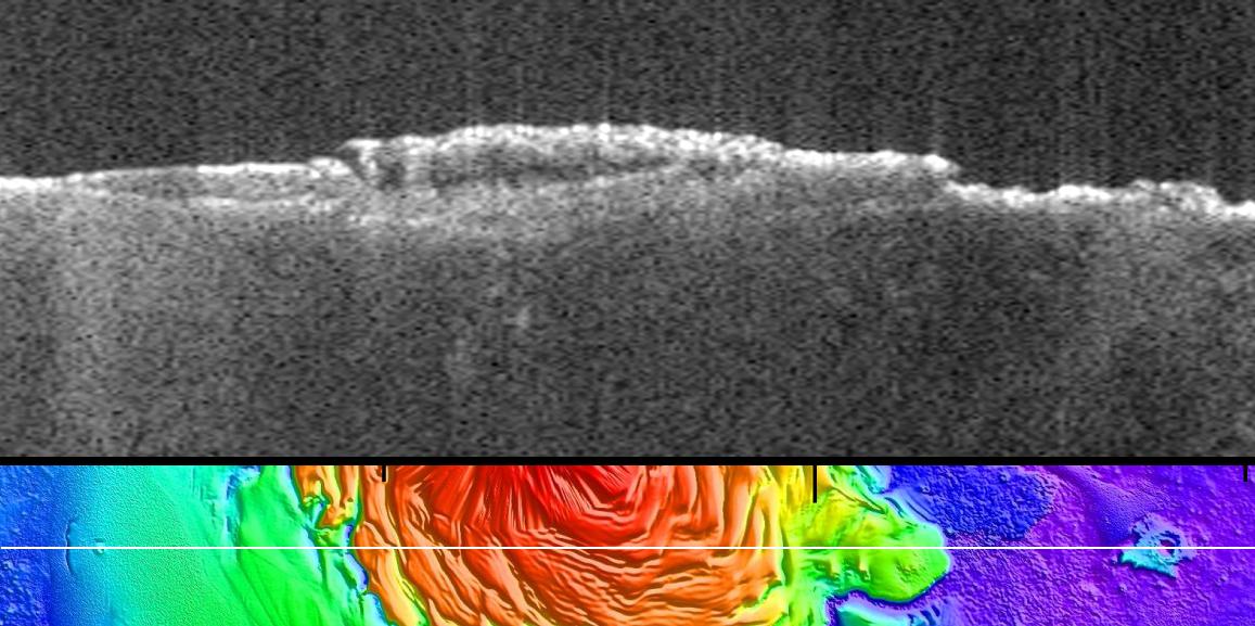
Radargram of Mars North Polar Plateau from Mars Express
- Click the image above for a larger view
- Full-Res JPEG (1157 x 577) (120.0 kB)
- Full-Res TIFF (1157 x 577) (2.0 MB)
Caption:
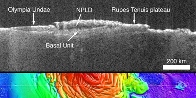
Figure 1
Click on the image for larger view
The upper panel is a radargram profile from the Mars Advanced Radar for Subsurface and Ionospheric Sounding (MARSIS), showing data from the subsurface of Mars in the ice-rich north polar plateau of Mars. It shows layers detected to a depth of about 1.5 miles (2.7 kilometers) beneath the surface in a transect about 930 miles (1,500 kilometers) long. A basal unit of a sand- and dust-rich icy material comprises more than half of the bulk of the polar plateau in this radargram profile. Its base can be traced from beneath the Olympia Undae sand sea at left, across the entire polar stack, to the margin of the Rupes Tenuis plateau at right, where there are no overlying north polar layered deposits (NPLD). The vertical dimension is time delay of radio-signal echo. The apparent deepening of the basal unit's lower boundary at the center is an artifact of the slowing of the radar wave in the icy material. In fact, the lower boundary is nearly flat.
The lower panel shows the path of the spacecraft ground track while these radar observations were being made, on a topographical map derived from Mars Orbiter Laser Altimeter data. Total relief in the topography from highest (red) to lowest (purple) is 1.7 miles (2.7 kilometers).
MARSIS is an instrument on the European Space Agency's Mars Express orbiter. MARSIS was developed by the University of Rome, Italy, in partnership with NASA's Jet Propulsion Laboratory in Pasadena, California. The Mars Orbiter Laser Altimeter flew on NASA's Mars Global Surveyor orbiter.
Cataloging Keywords:
| Name | Value | Additional Values |
|---|---|---|
| Target | Mars | |
| System | ||
| Target Type | Planet | |
| Mission | Mars Express (MEX) | Mars Express, Mars Global Surveyor (MGS) |
| Instrument Host | Mars Express Orbiter | Mars Express, Mars Global Surveyor |
| Host Type | Orbiter | |
| Instrument | Mars Advanced Radar for Subsurface and Ionosphere Sounding (MARSIS) | Mars Orbiter Laser Altimeter (MOLA) |
| Detector | ||
| Extra Keywords | Color, Dust, Map, Radar, Radio | |
| Acquisition Date | ||
| Release Date | 2011-12-19 | |
| Date in Caption | ||
| Image Credit | ESA/NASA/JPL-Caltech/Univ. of Rome/ASI/GSFC | |
| Source | photojournal.jpl.nasa.gov/catalog/PIA15117 | |
| Identifier | PIA15117 | |