
|
Topography and Albedo Image of Different Preservations States of Craters
- Click the image above for a larger view
- Full-Res JPEG (2600 x 1400) (265.2 kB)
- Full-Res TIFF (2600 x 1400) (10.9 MB)
Caption:
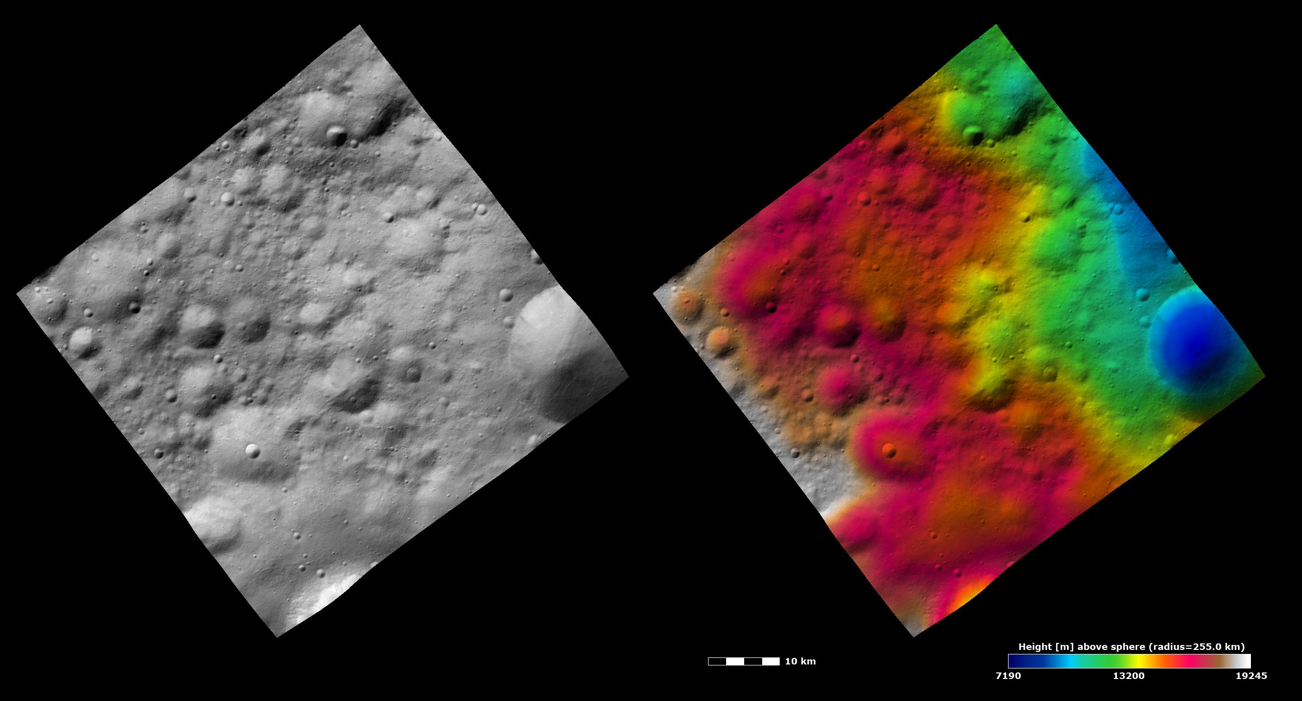
These Dawn FC (framing camera) images show many craters, which have different states of preservation, in Vesta's Bellicia quadrangle in the northern hemisphere. The left image is an albedo image, which is taken directly through the clear filter of the FC. Such an image shows the albedo (e.g. brightness/darkness) of the surface. The right image uses the same albedo image as its base but then a color-coded height representation of the topography is overlain onto it. The topography is calculated from a set of images that were observed from different viewing directions, allowing stereo reconstruction. The various colors correspond to the height of the area. The red area in the left and center of the image is the highest area and the blue area in the right of the image is the lowest area. The large crater in the right of the image is seen to have a fresh rim in the albedo image. The freshness of this rim is also shown in the topography image as a sharp contrast between a higher (colored green) and lower (colored blue) height. The more degraded craters in the center of the left of the image have smoother rims and do not have such a sharp height contrast along their rims. Also, these images display the varying roughness across Vesta's surface. The area next to the large crater in the right of the image is smoother and the rest of the area in the image is rougher. The area next to the large crater is probably an area of ejecta from the large, fresh crater because ejecta blankets are generally smoother than the areas surrounding them.
These images are centered in Vesta's Bellicia quadrangle and the center latitude and longitude of the image is 24.8°N, 65.6°E. NASA's Dawn spacecraft obtained this image with its framing camera on October 27th 2011. This image was taken through the camera's clear filter. The distance to the surface of Vesta is 700 km and the image has a resolution of about 60 meters per pixel. This image was acquired during the HAMO (High Altitude Mapping Orbit) phase of the mission. The images are lambert-azimuthal map projected.
Background Info:
The Dawn mission to Vesta and Ceres is managed by NASA's Jet Propulsion Laboratory, a division of the California Institute of Technology in Pasadena, for NASA's Science Mission Directorate, Washington D.C. UCLA is responsible for overall Dawn mission science. Dawn's VIR was provided by ASI, the Italian Space Agency and is managed by INAF, Italy's National Institute for Astrophysics, in collaboration with Selex Galileo, where it was built.
More information about Dawn is online at http://www.nasa.gov/dawn and http://dawn.jpl.nasa.gov .
Cataloging Keywords:
| Name | Value | Additional Values |
|---|---|---|
| Target | 4 Vesta | |
| System | Main Belt | |
| Target Type | Asteroid | |
| Mission | Dawn | |
| Instrument Host | Dawn | |
| Host Type | Orbiter | |
| Instrument | Framing Camera (FC) | |
| Detector | ||
| Extra Keywords | Color, Crater, Infrared, Map | |
| Acquisition Date | ||
| Release Date | 2011-11-30 | |
| Date in Caption | ||
| Image Credit | NASA/JPL-Caltech/UCLA/MPS/DLR/IDA | |
| Source | photojournal.jpl.nasa.gov/catalog/PIA15128 | |
| Identifier | PIA15128 | |