|
Paint It Black
- Click the image above for a larger view
- Full-Res JPEG (581 x 291) (35.2 kB)
- Full-Res TIFF (581 x 291) (508.0 kB)
Caption:
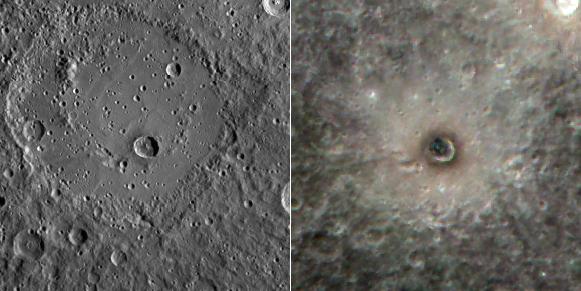
Today's offering shows two views of the crater Berkel . The image on the left is a monochrome image obtained when the Sun was lower on the horizon than when the color image on the right was collected. As a result, the left image emphasizes the topography of the surface (due to the presence of shadowing), whereas the image on the right is dominated by inherent differences in reflectance and color. The impact that formed Berkel excavated dark subsurface material and deposited it around the crater's rim. The presence of this low reflectance material causes the floor of the crater to appear black in the color image.
The image on the left is part of MDIS's high-resolution surface morphology base map. The surface morphology base map covers more than 90% of Mercury's surface with an average resolution of 250 meters/pixel (0.16 miles/pixel or 820 feet/pixel). Images acquired for the surface morphology base map typically have off-vertical Sun angles (i.e., high incidence angles) and visible shadows so as to reveal clearly the topographic form of geologic features.
The image on the right image is part of MDIS's color base map. The color base map is composed of WAC images taken through eight different narrow-band color filters and covers more than 90% of Mercury's surface with an average resolution of 1 kilometer/pixel (0.6 miles/pixel). The highest-quality color images are obtained for Mercury's surface when both the spacecraft and the Sun are overhead, so these images typically are taken with viewing conditions of low incidence and emission angles. The false-color presentation here has images taken through the 750-nm, 560-nm and 480-nm filters as red-green-blue.
Scale:
Berkel crater is about 22 km (14 mi.) in diameter
Location:
Berkel is located at -13.75° latitude, 26.9° E longitude
Instrument:
Mercury Dual Imaging System (MDIS)
Background Info:
The MESSENGER spacecraft is the first ever to orbit the planet Mercury, and the spacecraft's seven scientific instruments and radio science investigation are unraveling the history and evolution of the Solar System's innermost planet. Visit the Why Mercury? section of this website to learn more about the key science questions that the MESSENGER mission is addressing. During the one-year primary mission, MDIS is scheduled to acquire more than 75,000 images in support of MESSENGER's science goals.
These images are from MESSENGER, a NASA Discovery mission to conduct the first orbital study of the innermost planet, Mercury. For information regarding the use of images, see the MESSENGER image use policy .
Cataloging Keywords:
| Name | Value | Additional Values |
|---|---|---|
| Target | Mercury | |
| System | ||
| Target Type | Planet | |
| Mission | MESSENGER | |
| Instrument Host | MESSENGER | |
| Host Type | Orbiter | |
| Instrument | Mercury Dual Imaging System (MDIS) | |
| Detector | ||
| Extra Keywords | Color, Crater, Impact, Map, Radio, Shadow | |
| Acquisition Date | ||
| Release Date | 2012-01-23 | |
| Date in Caption | ||
| Image Credit | NASA/Johns Hopkins University Applied Physics Laboratory/Carnegie Institution of Washington | |
| Source | photojournal.jpl.nasa.gov/catalog/PIA15334 | |
| Identifier | PIA15334 | |