|
Mercury’s Topography from MLA
- Click the image above for a larger view
- Full-Res JPEG (760 x 780) (128.3 kB)
- Full-Res TIFF (760 x 780) (1.8 MB)
Caption:
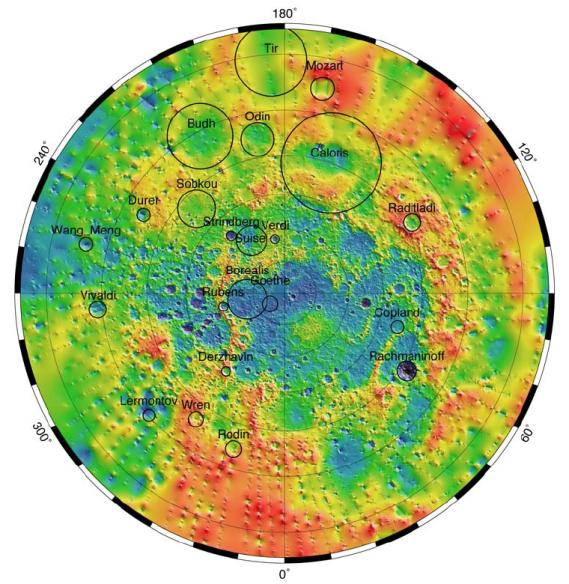
The Mercury Laser Altimeter (MLA) ranges at a wavelength of 1064 nm at an 8 Hz rate and illuminates Mercury's surface in spots between 15 and 100 m across, depending on the MESSENGER spacecraft's range. The MLA has so far returned 10.7 million precise measurements of the elevation of Mercury's northern hemisphere. Shown here is a polar stereographic projection of the topography of Mercury from the north pole to 5° S. The outlines of selected major impact structures are shown as black circles.
Background Info:
The MESSENGER spacecraft is the first ever to orbit the planet Mercury, and the spacecraft's seven scientific instruments and radio science investigation are unraveling the history and evolution of the Solar System's innermost planet. Visit the Why Mercury? section of this website to learn more about the key science questions that the MESSENGER mission is addressing. During the one-year primary mission, MDIS acquired 88,746 images and extensive other data sets. MESSENGER is now in a year-long extended mission, during which plans call for the acquisition of more than 80,000 additional images to support MESSENGER's science goals.
These images are from MESSENGER, a NASA Discovery mission to conduct the first orbital study of the innermost planet, Mercury. For information regarding the use of images, see the MESSENGER image use policy .
Cataloging Keywords:
| Name | Value | Additional Values |
|---|---|---|
| Target | Mercury | |
| System | ||
| Target Type | Planet | |
| Mission | MESSENGER | |
| Instrument Host | MESSENGER | |
| Host Type | Orbiter | |
| Instrument | Mercury Laser Altimeter (MLA) | |
| Detector | ||
| Extra Keywords | Color, Impact, Radio | |
| Acquisition Date | ||
| Release Date | 2012-03-21 | |
| Date in Caption | ||
| Image Credit | NASA/Johns Hopkins University Applied Physics Laboratory/Carnegie Institution of Washington | |
| Source | photojournal.jpl.nasa.gov/catalog/PIA15529 | |
| Identifier | PIA15529 | |